

Fairytale hiking trail


- Suitable for families
- Flatly
Interactive elevation profile
Create PDF
Tour-Details
Starting place: 4091 Vichtenstein
Destination: 4091 Vichtenstein
duration: 0h 39m
length: 2,4 km
Altitude difference (uphill): 63m
Altitude difference (downhill): 63m
Lowest point: 549m
Highest point: 612m
difficulty: easy
condition: very easy
panoramic view: Dreamtour
Paths covering:
Asphalt, Other
powered by TOURDATA
Short description:
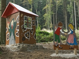
A squirrel accompanies visitors on the 2 km long, well walk-on-able, gravelled forest and meadow path. Fairytale characters meet you on this walk.
A squirrel accompanies visitors on the 2 km long, well walk-on-able, gravelled forest and meadow path. Fairytale characters meet you on this walk.
Technique: *
Quality of experience: ****
Recommended season:
- April
- May
- June
- July
- August
- September
- October
Properties:
- Loop
- Refreshment stops available
- Family friendly
Viewing platform in front of the town hall - past the parish church, passing the primary school on the right along the fairytale hiking trail - the fairytale hiking trail also leads past a fallow deer enclosure.
Tip:
The hiking trail is particularly suited for families with children.
Starting point: Vichtenstein municipal office
Destination: Vichtenstein municipal office
further information:
- Flatly
- Board possible
Accessibility / arrival
Parking
Vichtenstein town hall
Public Transit
Location and getting there
How to arrive in the Danube Upper Austrian region?
The fast way to your destination – by train, bus, car, boat or plane.
Parking
Vichtenstein town hall
Most economical season
- Spring
- Summer
- Autumn
Please get in touch for more information.
Vichtenstein 70
4091 Vichtenstein
Phone +43 7714 8055
E-Mail gemeinde@vichtenstein.ooe.gv.at
Web www.vichtenstein.at
http://www.vichtenstein.at
Interactive elevation profile
Create PDF
Tour-Details
Starting place: 4091 Vichtenstein
Destination: 4091 Vichtenstein
duration: 0h 39m
length: 2,4 km
Altitude difference (uphill): 63m
Altitude difference (downhill): 63m
Lowest point: 549m
Highest point: 612m
difficulty: easy
condition: very easy
panoramic view: Dreamtour
Paths covering:
Asphalt, Other
powered by TOURDATA