

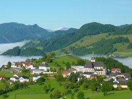
Freithofberg


- Flatly
Interactive elevation profile
Create PDF
Tour-Details
Path number: E31, E31a
Starting place: 4443 Maria Neustift
Destination: 4443 Maria Neustift
duration: 1h 30m
length: 4,6 km
Altitude difference (uphill): 346m
Altitude difference (downhill): 7m
Lowest point: 606m
Highest point: 952m
difficulty: easy
condition: easy
panoramic view: Dreamtour
Paths covering:
Asphalt, Gravel, Street, Hiking trail, Other
powered by TOURDATA
Short description:
Popular excursion destination for short hikes and walksand with wonderful all-round views
Popular excursion destination for short hikes and walksand with wonderful all-round views
Recommended season:
- March
- April
- May
- June
- July
- August
- September
- October
- November
- December
Properties:
- Loop
- Scenic
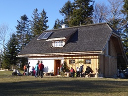
- Refreshment stops available
- Summit route
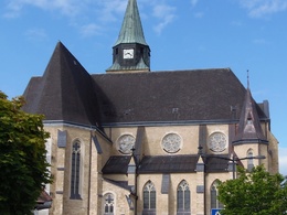
Starting from the church square in Maria Neustift, different paths lead to the Freithofberg - extended circular hike, panoramic path or summit path.
Trail number: E31, E31a, E31b
Directions:
From the church square in Maria Neustift, the E31 leads up the Freithofberg. At the beginning, the hiking trail runs up the mountain on an asphalt road. It continues over a meadow ridge, then on a gravel path, over a meadow and through a short section of forest. Even during the hike and when you arrive at your destination, you are rewarded with magnificent panoramas.
Variants:
- Freithofberg circular route from the church square to the Weger farmhouse, the route is on asphalt and from there the mountain is circled on the left, past the turn-off to Konradsheim, at the Moosgraben fire station. After a short stretch on the main road, you leave it on the right, walk past some farmhouses and soon have the pilgrimage church of Maria Neustift in view again.
- Panorama trail Freithofberg on the asphalt road to the Krendlberg farmhouse and from there on the gravel road and hiking trail to the Freithofbergalm.
Starting point: Maria Neustift/church
Destination: Maria Neustift/church
further information:
- Flatly
- Board possible
Accessibility / arrival
Public Transit
The Ennstalbahn runs between Linz and Weißenbach-St. Gallen.
Parking
parking in the center of the village
Getting there
From Salzburg/Linz: A1 motorway exit Enns-Steyr > B115 into the Enns Valley.
From Vienna: A1 motorway exit Haag > B42 > B122 > B115 into the Enns Valley
From Passau: A8 Passau > Wels > A1 motorway exit Enns-Steyr > B115 into the Enns Valley
From Graz: A9 Pyhrnautobahn > motorway exit Klaus > Grünburg > into the Ennstal valley
Public Transit
The Ennstalbahn runs between Linz and Weißenbach-St. Gallen.
Details at www.ooevv.at
Railway Stations are located in Ternberg, Trattenbach, Losenstein, Reichraming, Großraming, Gaflenz, Weyer, Küpfern, Kastenreith, Kleinreifling and Weißenbach-St. Gallen.
Parking
parking in the center of the village
Most economical season
- Spring
- Summer
- Autumn
- Early winter
- Deep winter
Please get in touch for more information.
Stadtplatz 27
4400 Steyr
Phone +43 7252 53229 - 0
E-Mail reichraming@steyr-nationalpark.at
Web www.steyr-nationalpark.at/
https://www.steyr-nationalpark.at/
Interactive elevation profile
Create PDF
Tour-Details
Path number: E31, E31a
Starting place: 4443 Maria Neustift
Destination: 4443 Maria Neustift
duration: 1h 30m
length: 4,6 km
Altitude difference (uphill): 346m
Altitude difference (downhill): 7m
Lowest point: 606m
Highest point: 952m
difficulty: easy
condition: easy
panoramic view: Dreamtour
Paths covering:
Asphalt, Gravel, Street, Hiking trail, Other
powered by TOURDATA