

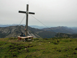
Hoher Zinken Mountain


Interactive elevation profile
Create PDF
Tour-Details
Path number: Nr. 857, 840
Starting place: 5342 Abersee - St. Gilgen
Destination: 5342 Abersee - St. Gilgen
duration: 5h 53m
length: 13,3 km
Altitude difference (uphill): 1.261m
Altitude difference (downhill): 83m
Lowest point: 563m
Highest point: 1.748m
difficulty: medium
condition: medium
panoramic view: Some Views
Paths covering:
Asphalt, Gravel, Hiking trail
powered by TOURDATA
A long, pretty hike leading through a valley for a considerable time before the climb begins. A hike on the wide Zinkenbach River forest road leading along the Königsbach Stream, passing the Königsbachalm mountain pastures to the Wetzsteingraben. From here it continues to a hunting cabin, and the last few metres follow route no. 840 to the 1,764 m high summit of the Hohen Zinken Mountain.
Parking
- Parking space: 10
- Suitable for single travelers
- Suitable for friends
- Suitable for couples
- Spring
- Summer
- Autumn
Please get in touch for more information.
Mondsee Bundesstraße 1a
5350 Strobl
Phone +43 6227 2348
Fax machine +43 6227 2348 - 9
E-Mail stgilgen@wolfgangsee.at
Web wolfgangsee.at
http://wolfgangsee.at
Interactive elevation profile
Create PDF
Tour-Details
Path number: Nr. 857, 840
Starting place: 5342 Abersee - St. Gilgen
Destination: 5342 Abersee - St. Gilgen
duration: 5h 53m
length: 13,3 km
Altitude difference (uphill): 1.261m
Altitude difference (downhill): 83m
Lowest point: 563m
Highest point: 1.748m
difficulty: medium
condition: medium
panoramic view: Some Views
Paths covering:
Asphalt, Gravel, Hiking trail
powered by TOURDATA