

Mountainbikestrecke: Granitlandrunde


- Flatly
- Possible accommodation
Interactive elevation profile
Create PDF
Tour-Details
Path number: 1
Starting place: 4162 Julbach
Destination: 4162 Julbach
duration: 23h 0m
length: 258,0 km
Altitude difference (uphill): 7.308m
Altitude difference (downhill): 7.305m
Lowest point: 280m
Highest point: 939m
difficulty: medium
condition: medium
panoramic view: Great panorama
Paths covering:
Asphalt, Path / trail
powered by TOURDATA
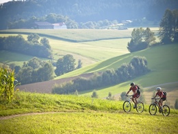
The large Granitland tour takes you to all the communities in the mountain bike region.
On the individual sections of the route, you will encounter granite in its most diverse forms. Experience the scenic diversity of the Mühlviertel on breathtaking climbs, technically challenging trails and fantastic descents: gentle hills, charming valleys, long forests and panoramic spots with far-reaching views.
On the individual sections of the route, you will encounter granite in its most diverse forms. Experience the scenic diversity of the Mühlviertel on breathtaking climbs, technically challenging trails and fantastic descents: gentle hills, charming valleys, long forests and panoramic spots with far-reaching views.
The route characteristics are varied and the course is coordinated with sights and natural sites. MTB catering and specialist partners will look after you along the entire route. However, you can start anywhere. You and your ability decide how many days you take for the Granitland Tour adventure. If luggage transfer is necessary, this will be organised by the accommodation providers.
Use the free outdooractive app to navigate the route.
further information:
- Flatly
- Possible accommodation
- Board possible
details mountainbike
- Riding technique: medium
Most economical season
- Spring
- Summer
- Autumn
Please get in touch for more information.
Schulstraße 4
4162 Julbach
Phone +43 5 7890 - 100
Fax machine +43 5 7890 - 115
E-Mail info@boehmerwald.at
Web www.boehmerwald.at
https://www.boehmerwald.at
You can also visit us on
Visit us on Facebook Visit us on Twitter")
")
Interactive elevation profile
Create PDF
Tour-Details
Path number: 1
Starting place: 4162 Julbach
Destination: 4162 Julbach
duration: 23h 0m
length: 258,0 km
Altitude difference (uphill): 7.308m
Altitude difference (downhill): 7.305m
Lowest point: 280m
Highest point: 939m
difficulty: medium
condition: medium
panoramic view: Great panorama
Paths covering:
Asphalt, Path / trail
powered by TOURDATA