

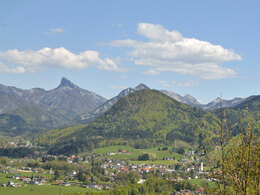
Hike around the "Zuckerhut" mountain


- Suitable for families
- Suitable for kids (all ages)
- Flatly
Interactive elevation profile
Create PDF
Tour-Details
Paths covering:
The circular trail begins at the junction at the Musikheim (just before the sports field) at the eastern end of the village with the Kasbergweg (W431).
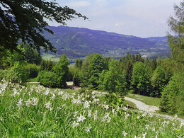
Via the "Waldweg", to the Irreralm, where the daffodils bloom wonderfully in spring. Continue along the circular trail around the Zuckerhut via the "Tiefer Weg" hiking trail to the starting point in the village of Grünau im Almtal.
The meadows and forest are privat property - we therefore respect the rights of the landowners and take care of the nature!
Forest deserves respect!
further information:
- Flatly
How to get to the Almtal (to Grünau im Almtal):
We recommend that you travel by public transport!
by train: from Wels train station with the Almtalbahn (line 153) to Grünau im Almtal;
Numerous connections from Wels station to the main trains on the western line (line 101)
by bus: OÖVV bus line 533 Almsee - Grünau - Gmunden
with the Traunstein Taxi Route 60 from Grünau railway station to the Sportplatz, Bauerwirt or Enzenbachmühle stop, depending on the tour. Min. call the taxi headquarters 1 hour in advance on 050-422 1691 or order on the otaxi app.
by walking: From the Grünau im Almtal train station, you can walk comfortably through the village center to the sports field and start the hike.
by bicycle:
On the Almtalradweg R11 to Grünau im Almtal, at the Almbrücke after the train station, turn left into the center and follow the street, at the intersection at the SPAR Markt straight ahead up the mountain next to the church to the sports field.
by car:
West motorway A1: Vienna - Voralpenkreuz-A9 - exit Ried / Tr. - Voitsdorf - Pettenbach - Scharnstein - Grünau
West motorway A1: Munich - Salzburg - Regau - Gmunden - Scharnstein - Grünau
Innkreis motorway A8 Passau - Wels - Voralpenkreuz A9 - exit Ried / Tr. - Voitsdorf - Pettenbach - Scharnstein - Grünau
From the center of Grünau, drive past the parish church and the cemetery in the direction of Kasberg. On the right-hand side after the cemetery wall, turn right into Waldwegstraße. Parking at the sports field.
Follow the signs from there!
- Parking space: 80
- Parking area for disabled: 4
free parking spots
Shuttle serviceTraunstein Taxi, Route 60
- Free entry
- Suitable for groups
- Suitable for schools
- Suitable for kids (all ages)
- Suitable for single travelers
- Suitable for friends
- Suitable for couples
- Suitable for children
- Spring
- Summer
- Autumn
Please get in touch for more information.
Im Dorf 17
4645 Grünau im Almtal
Phone +43 7616 8268
E-Mail almtal@traunsee-almtal.at
Web www.traunsee-almtal.at
Web www.gruenau.ooe.gv.at/
http://www.gruenau.ooe.gv.at/
")
")
Interactive elevation profile
Create PDF
Tour-Details
Paths covering: