

In the footsteps of the Black Counts


- All weather
- Suitable for families
- Suitable for pushchairs
- culturally interesting
- Flatly
Interactive elevation profile
Create PDF
Tour-Details
Path number: Themenweg
Starting place: 4592 Grünburg
Destination: 4592 Grünburg
duration: 1h 12m
length: 4,1 km
Altitude difference (uphill): 140m
Altitude difference (downhill): 140m
Lowest point: 380m
Highest point: 442m
difficulty: easy
condition: easy
panoramic view: Individual Views
Paths covering:
Asphalt, Gravel, Street, Hiking trail, Other
powered by TOURDATA
Short description:
Idyllic circular trail along the Rinnerberg stream into the valley of the Black Counts
Idyllic circular trail along the Rinnerberg stream into the valley of the Black Counts
Quality of experience: ***
Recommended season:
- March
- April
- May
- June
- July
- August
- September
- October
- November
- December
Properties:
- Loop
- Family friendly
- Cultural/historical value
- Suitable for strollers
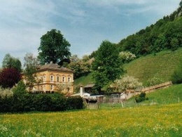
At Leonstein Castle, the idyllic circular trail branches off into the valley of the Black Counts. Along the Rinnerberger Bach stream, you penetrate further and further into the deeply incised valley. Beautiful manor houses, forge and servants' quarters and the impressive landscape are waiting to be discovered.
Directions:
At Leonstein Castle, the idyllic circular trail branches off into the valley of the Black Counts. Along the Rinnerberger Bach stream, you penetrate further and further into the deeply incised valley. Beautiful manor houses, forge and servants' quarters and the impressive landscape are waiting to be discovered. There is a lot to observe.
Special feature: open-air museum Schmiedleithen and guided hikes
Tip:
The path is especially attractive for our little ones: While constantly walking along the creek, you pass by sheep, ducks, turkeys, horses, fish, goats and even peacocks. There's all sorts to observe.
Starting point: Grünburg/Schloss Leonstein
Destination: Grünburg/Schloss Leonstein
further information:
- Flatly
Details - hiking
- themed path
Accessibility / arrival
Public Transit
The Steyrtal is served by bus lines 452 (Rohr-Bad Hall-Steinbach a. d. Steyr) and 433 (Steyr-Molln-Kirchdorf).
Parking
Grünburg/parking at Schloss Leonstein
Getting there
From the west: A1 exit Sattledt > via Kremsmünster > Bad Hall > Steinbach an der Steyr
From the east: A1 exit Haag > Steyr > B140 into the Steyr valley
From the north: A3 Passau > Wels > A9 exit Sattledt > Kremsmünster > Bad Hall > Steinbach
From the south: A9 exit Klaus > into the Steyr valley
Public Transit
The Steyrtal is served by bus lines 452 (Rohr-Bad Hall-Steinbach a. d. Steyr) and 433 (Steyr-Molln-Kirchdorf).
Details at www.ooevv.at
With the Steyrtal Museum Railway www.steyrtalbahn.at
Parking
Grünburg/parking at Schloss Leonstein
- All weather
- Suitable for groups
- Suitable for schools
- Suitable for pushchairs
- Spring
- Summer
- Autumn
- Early winter
- Deep winter
Please get in touch for more information.
Stadtplatz 27
4400 Steyr
Phone +43 7252 53229 - 0
E-Mail reichraming@steyr-nationalpark.at
Web www.steyr-nationalpark.at/
https://www.steyr-nationalpark.at/
Interactive elevation profile
Create PDF
Tour-Details
Path number: Themenweg
Starting place: 4592 Grünburg
Destination: 4592 Grünburg
duration: 1h 12m
length: 4,1 km
Altitude difference (uphill): 140m
Altitude difference (downhill): 140m
Lowest point: 380m
Highest point: 442m
difficulty: easy
condition: easy
panoramic view: Individual Views
Paths covering:
Asphalt, Gravel, Street, Hiking trail, Other
powered by TOURDATA