

height cycle


- Suitable for families
- culinary interesting
- culturally interesting
- Flatly
- Possible accommodation
Interactive elevation profile
Create PDF
Tour-Details
Path number: 907
Starting place: 4251 Sandl
Destination: 4251 Sandl
duration: 1h 22m
length: 17,0 km
Altitude difference (uphill): 312m
Altitude difference (downhill): 315m
Lowest point: 790m
Highest point: 1.007m
difficulty: difficult
condition: difficult
panoramic view: Dreamtour
Paths covering:
Asphalt
powered by TOURDATA
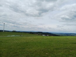
The high-altitude cycle path bears its degree of difficulty but also its beauty in its name! The tour starts at the Sandl municipal office; You have to master some considerable climbs on this route, but the scenery is all the more breathtaking for it. The tour leads past the 1,112 metre-high Viehberg and the Viehberghütte, which invites you to linger.
Not far away is also the Summit Cross of the Viehberg and the Maltschursprung!
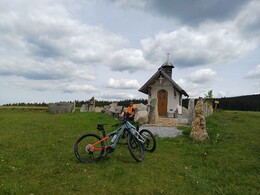
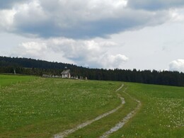
At kilometre 10, you can take a break at the Spörbichl chapel and enjoy the magnificent views of the Mühlviertel hills.
A section of the cycle path runs parallel to the R5 cycle path. This cycle tour can be easily combined with the cycle path no. 906 "Viehberg-Maltsch-Radroute" from/to Windhaag bei Freistadt (approx. 23 km) or with the cycle route no. 908 "Power-Radroute" from/to St. Oswald bei Freistadt.
Not far away is also the Summit Cross of the Viehberg and the Maltschursprung!
At kilometre 10, you can take a break at the Spörbichl chapel and enjoy the magnificent views of the Mühlviertel hills.
A section of the cycle path runs parallel to the R5 cycle path. This cycle tour can be easily combined with the cycle path no. 906 "Viehberg-Maltsch-Radroute" from/to Windhaag bei Freistadt (approx. 23 km) or with the cycle route no. 908 "Power-Radroute" from/to St. Oswald bei Freistadt.
Starting point: Community centre (Parking at the tennis court at the entrance to the village)
Destination: Community centre (Parking at the tennis court at the entrance to the village)
further information:
- culinary interesting
- Flatly
- Possible accommodation
- Board possible
")

")
")


")

General price information
No Cost!
- Free entry
- voluntary contribution
- Suitable for groups
- Suitable for schools
- Spring
Please get in touch for more information.

Sandl 24
4251 Sandl
Phone +43 7944 8255
E-Mail gemeinde@sandl.ooe.gv.at
Web sandl.at/
https://sandl.at/
Interactive elevation profile
Create PDF
Tour-Details
Path number: 907
Starting place: 4251 Sandl
Destination: 4251 Sandl
duration: 1h 22m
length: 17,0 km
Altitude difference (uphill): 312m
Altitude difference (downhill): 315m
Lowest point: 790m
Highest point: 1.007m
difficulty: difficult
condition: difficult
panoramic view: Dreamtour
Paths covering:
Asphalt
powered by TOURDATA