

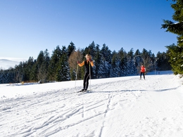
Schwarzenberg cross-country ski trail


- Flatly
- Possible accommodation
Interactive elevation profile
Create PDF
Tour-Details
Path number: 7
Starting place: 4164 Schwarzenberg am Böhmerwald
Destination: 4164 Schwarzenberg am Böhmerwald
duration: 0h 30m
length: 3,0 km
Altitude difference (uphill): 46m
Altitude difference (downhill): 62m
Lowest point: 679m
Highest point: 742m
difficulty: easy
condition: medium
panoramic view: Great panorama
Paths covering:
snow
powered by TOURDATA
Trail not in operation
Schwarzenberg trail network:Schwarzenberg trail, 3 km, P + S Please enquire about the snow conditions at the tourist information centre +43 057890 100 or online via the current trail report! This is updated daily from the first snowfall!
Request our free cross-country ski trail map here!
We will be happy to add you to our mailing list for the daily cross-country ski trail report - a short e-mail is enough: info@boehmerwald.at!
Starting point: Fire brigade depot.
Destination: Fire brigade depot.
further information:
- Flatly
- Possible accommodation
- Board possible
Details - Trail
- Type of Nordic skiing run: Classic + skating
- free
Depending on snow conditions and weather.
General price information
No trail fee!
Most economical season
- Deep winter
Please get in touch for more information.
Hauptstraße 4
4164 Schwarzenberg am Böhmerwald
Phone +43 7280 255
Fax machine +43 7280 255 - 4
E-Mail info@boehmerwald.at
Web www.schwarzenberg.co.at
https://www.schwarzenberg.co.at
You can also visit us on
Visit us on Facebook Visit us on Instagram Visit our videochannel on YouTubeInteractive elevation profile
Create PDF
Tour-Details
Path number: 7
Starting place: 4164 Schwarzenberg am Böhmerwald
Destination: 4164 Schwarzenberg am Böhmerwald
duration: 0h 30m
length: 3,0 km
Altitude difference (uphill): 46m
Altitude difference (downhill): 62m
Lowest point: 679m
Highest point: 742m
difficulty: easy
condition: medium
panoramic view: Great panorama
Paths covering:
snow
powered by TOURDATA