

Guggenberg - Weißenstein - Prielbauer


- All weather
- Suitable for families
- Suitable for pushchairs
- Flatly
Interactive elevation profile
Create PDF
Tour-Details
Starting place: 5310 Mondsee am Mondsee
Destination: 5310 Mondsee am Mondsee
duration: 2h 0m
length: 7,3 km
Altitude difference (uphill): 121m
Altitude difference (downhill): 118m
Lowest point: 495m
Highest point: 617m
difficulty: easy
condition: easy
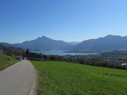
panoramic view: Individual Views
Paths covering:
Asphalt
powered by TOURDATA
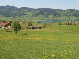
Hiking trail suitable for winter over the Guggenberg and through the Weißenstein settlement.
We follow the Herzog-Odilo-Street in northern direction to the motorway bridge and take the first right - immediately after the underpass. Slightly uphill this street leads us (path no. 32) through the districts of Schlössl and Zur Linde. At Guggenbergstrasse we turn left and walk down west to the main road, which we cross at the warehouse.
We are in the Weißenstein district and continue straight ahead. Before the road leads downhill to Haidermühle, we can turn left towards the south and thus stay on the ridge. We hike back on Vogelsangstrasse with the beautiful view of the mountains of the Mondseeland.
We ignore the turnoff to the Erlachmühle. In the following left curve, a dirt road branches off to the right. This leads us to the sports center and straight ahead under the autobahn through to Prielhofstrasse. The beautifully situated Prielhof used to belong to the Mondsee monastery or castle. The path leads past Sportland and the Red Cross point. We reach the roundabout via Prielhofstrasse. Through the underpass we come to the fire brigade and to Krankenhausstrasse, which we follow downhill. At the next crossroads we turn left, cross Steinerbachstrasse and come back to Herzog-Odilo-Strasse and back to the center on Freinbergerstrasse.
This tour including a description was made available to us by the Alpenverein Österreich, Mondsee Section, Mrs. Annelu-Ilse Wenter.
Starting point: Tourism Association Mondsee-Irrsee, Dr. Franz Müller Str. 3 - in the center of Mondsee. Parking at the lake promenade!
Destination: Tourism Association Mondsee-Irrsee, Dr. Franz Müller Str. 3 - in the center of Mondsee.
further information:
- Flatly
Details - hiking
- cleared winter hiking path
")
")
")
Accessibility / arrival Parking
The tour starts at the Mondsee-Irrsee tourist office in the center of Mondsee. Free parking is available at the Mondsee lake promenade.
- Parking space: 200
none
- All weather
- Suitable for groups
- Suitable for pushchairs
- Suitable for seniors
- Suitable for single travelers
- Suitable for couples
- Spring
- Summer
- Autumn
- Early winter
- Deep winter
Somewhat suitable for wheelchairs: Assistance is sometimes necessary. The measurements do not (fully) conform to the legally stipulated ÖNORM.
Dr. Franz Müller Straße 3
5310 Mondsee am Mondsee
Phone +43 6232 2270
E-Mail info@mondsee.at
Web www.mondsee.at
http://www.mondsee.at
Interactive elevation profile
Create PDF
Tour-Details
Starting place: 5310 Mondsee am Mondsee
Destination: 5310 Mondsee am Mondsee
duration: 2h 0m
length: 7,3 km
Altitude difference (uphill): 121m
Altitude difference (downhill): 118m
Lowest point: 495m
Highest point: 617m
difficulty: easy
condition: easy
panoramic view: Individual Views
Paths covering:
Asphalt
powered by TOURDATA