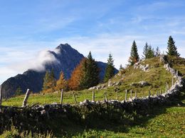
© Photo: Oberösterreich Tourismus GmbH./Robert Maybach: Enjoy the view in Upper Austria


Wildfrauensteig to the Bosruck (B/C)


- Suitable for families
Interactive elevation profile
Create PDF
Tour-Details
Path number: 613
Starting place: 4582 Spital am Pyhrn
Destination: 4582 Spital am Pyhrn
duration: 3h 39m
length: 3,7 km
Altitude difference (uphill): 946m
Altitude difference (downhill): 52m
Lowest point: 1.029m
Highest point: 1.952m
difficulty: medium
condition: difficult
panoramic view: Dreamtour
Paths covering:
Gravel, Hiking trail
powered by TOURDATA
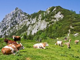
Airy ridge crossing of the Bosruck
How difficult is it?
You can expect mostly A/B sections, with a few C-points, but also climbing passages on rock with difficulty grade I. Because of the exposed, partly unsecured sections, good surefootedness is a basic requirement! Especially after rain or in fog, the grassy craggy sections are particularly slippery! We do not recommend walking on the trail when it is wet.
Details - climbing mount
- difficulty acc. to Kurt Schall: difficult (C)
- Hop off description: (1.5 h | 580 hm) Via the Ochsenwaldkapelle chapel you reach the Arlingalmen pastures and further on to the Arlingsattel at 1,425 m. Here the signs to the Wildfrauenklettersteig lead the way. A short detour down to the left to the portal of the Wildfrauenhöhle is worthwhile. From a prominent saddle, the rope belays begin. Attention - the course of the ridge is not continuously secured. Therefore, great caution is advised, especially at the breaks!
- Hop on description: (2.5 h | 1,000 m) After the summit cross, follow the marked path along the ridge in a westerly direction and you will first reach the Kitzstein and then the Lahnerkogel, which is also an exposed, partly rope-secured ridge hike. From here you descend via the Fuchsalm (1,051 m) to the Pyhrnpass (953 m).
- duration hop on: 1 h
- duration climbing mount: 2 h
- duration Descent: 2 h
June till October depending on weather
Accessibility / arrival
Spital am Pyhrn, car park below the Bosruckhütte (1,020 m)
- Suitable for single travelers
- Suitable for families
- Suitable for friends
- Suitable for couples
- Spring
- Summer
- Autumn
Please get in touch for more information.

Stiftsplatz 1
4582 Spital am Pyhrn
Phone +43 7563 249
Fax machine +43 7563 249 - 20
E-Mail spital@pyhrn-priel.net
Web www.urlaubsregion-pyhrn-priel.at
https://www.urlaubsregion-pyhrn-priel.at
You can also visit us on
Visit us on Facebook Visit us on Instagram Visit us on Pinterest Visit our videochannel on YouTubeInteractive elevation profile
Create PDF
Tour-Details
Path number: 613
Starting place: 4582 Spital am Pyhrn
Destination: 4582 Spital am Pyhrn
duration: 3h 39m
length: 3,7 km
Altitude difference (uphill): 946m
Altitude difference (downhill): 52m
Lowest point: 1.029m
Highest point: 1.952m
difficulty: medium
condition: difficult
panoramic view: Dreamtour
Paths covering:
Gravel, Hiking trail
powered by TOURDATA