

Bad Goisern, St. Agatha - Reitern - Stambach cross-country ski trail


Interactive elevation profile
Create PDF
Tour-Details
Paths covering:
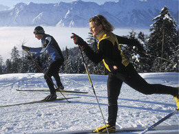
The St. Agatha - Reitern - Stambach cross-country ski trail in Bad Goisern on Lake Hallstatt - also known as the "Trüfö Loipe" - makes the heart of a pleasure cross-country skier beat faster.
Sunny, easy cross-country ski trail
This sunny, easy-to-master trail runs through three villages from Bad Goisern am Hallstättersee.
It is largely flat, without significant ascents and descents.
Enjoy the surrounding mountain world of the Inner Salzkammergut, be it on the diagonal or skating track.
TIP: The cross-country ski trail also leads to the small Catholic Filialkirche in St. Agatha.
Download the cross-country ski trail map of Bad Goisern here.
Experience a 360° panoramic tour through Bad Goisern on Lake Hallstatt...
Details - Trail
- Nordic skiing facilities: Marked Nordic skiing run
- Type of Nordic skiing run: Classic + skating
- free
December to March, depending on snow conditions.
Parking and access: in the village of Edt (entrance opposite the Aigner car dealership), a car park is cleared for cross-country skiers in the winter months.
By car
From Salzburg:
Exit Thalgau via the B158 federal road towards Bad Ischl, in Bad Ischl take the B145 Salzkammergut road towards Bad Goisern.
From Linz:
Regau motorway exit onto Salzkammergut Straße B145 towards Gmunden and Bad Ischl to Bad Goisern.
From Vienna/Graz:
Liezen motorway exit onto B320, in Trautenfels turn off onto Salzkammergut Straße B145 to Bad Goisern.
From Villach:
Tauern motorway to exit "Eben im Pongau", via B166 Pass Gschütt Bundesstraße through Gosau, turn left at the Gosaumühle junction towards Bad Goisern.
By train
Train Attnang-Puchheim - Stainach-Irdning:
Stops Goisern Jodschwefelbad, Bad Goisern railway station, Steeg / Gosau.
By bus
Bus 541 & 542 (Bad Ischl - Lake Gosau):
Stops Bad Goisern Jodschwefelbad, Bad Goisern Kurhotel, Bad Goisern Mitte/B145, Stambach StrKrzg., St. Agatha Agathawirt, Stambach Angerer, Steeg Reitern, Steeg Au, Steeg Bahnhof, Steeg Traunbrücke, Steeg E-Werk.
Detailed information on the respective train and bus times can be found here!
- Parking space: 5
All cross-country ski trails in the Goiserertal can be used free of charge.
- Free entry
- Suitable for schools
- Suitable for kids (6 - 14 Year)
- Suitable for teenagers
- Suitable for seniors
- Suitable for single travelers
- Suitable for friends
- Suitable for couples
- Deep winter
Please get in touch for more information.
")
Kirchengasse 4
4822 Bad Goisern am Hallstättersee
Phone +43 5 95095 - 10
E-Mail goisern@dachstein-salzkammergut.at
Web dachstein.salzkammergut.at
You can also visit us on
Visit us on Facebook Visit us on Instagram Visit us on TikTok Visit us on Pinterest Visit our videochannel on YouTube Wikipedia")
Interactive elevation profile
Create PDF
Tour-Details
Paths covering: