

lake Laudachsee mtb round tour


- Flatly
Interactive elevation profile
Create PDF
Tour-Details
Starting place: 4810 Gmunden
Destination: 4810 Gmunden
duration: 2h 0m
length: 15,7 km
Altitude difference (uphill): 590m
Altitude difference (downhill): 542m
Lowest point: 437m
Highest point: 928m
difficulty: medium
condition: medium
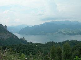
panoramic view: Great panorama
Paths covering:
Asphalt, Gravel
powered by TOURDATA
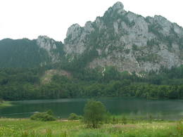
Idyllic Laudachsee is located high above Gmunden. Mountain bikers can reach this beautiful little lake via Grünberg where a trail branches off the Grünberg round tour and leads you to the lake Laudachsee. To get back take asphalted road "Laudachseestraße"
Please note that there are some steep sections on the route.
We start in Gmunden at the junction Himmelreichstr/Laudachseestraße (Engelbauer/Mülibankerl car park) on the eastern outskirts of Gmunden (access also possible from the Weyer/Grünbergseilbahn car park or from Engelhof railway station). We follow the Lemberg farm track (Himmelreichstraße) to the Grünbergbauer car park. After the car park, we take the Mitterweg path on the right, which is very steep and a bit rutted for a short while. We then take the path under the cables of the Grünberg cable car and continue uphill. This is followed by a short, trail-like section before returning to a forest road that leads past the ascent to the Grünbergalm inn (hiking trail only), continuing to the Radmoos junction (junction hiking trail in the direction of the Grünberberg cable car / Salzkammergut treetop path or in the direction of Laudachsee or Franzl im Holz). At the crossroads continue in the direction of Laudachsee following the forest road to the inn "Ramsauer Alm", briefly back and then the forest road Laudachsee to the gorge (Wamering), there in the direction of the inn Silberfuchs or Franzl im Holz, the asphalted Laudachseestraße back to the Engelbauer car park, possibly to the railway station or inn Engelhof.
Starting point: junction of Himmelreichstrasse/Laudachseestrasse (Engelbauer parking lot)
Destination: parking lot Engelbauer
further information:
- Flatly
details mountainbike
- Riding technique: medium
")
")
karl_heinz_ruber (8) (© Foto: TVB Traunsee-Almtal/Karl-Heinz Ruber)")
Accessibility / arrival
from the highway: departure Regau-B 145 in the diretcion of Bad Ischl-through the center of Gmunden-across the brigde "Traunbrücke"-turn right to the cable car "Grünbergseilbahn"
Most economical season
- Summer
Not suitable for wheelchairs. The property is not compliant with Austria's ÖNORM legal standard.
Toscanapark 1
4810 Gmunden
Phone +43 7612 74451
E-Mail info@traunsee-almtal.at
Web traunsee-almtal.salzkammergut.at/
https://traunsee-almtal.salzkammergut.at/
Interactive elevation profile
Create PDF
Tour-Details
Starting place: 4810 Gmunden
Destination: 4810 Gmunden
duration: 2h 0m
length: 15,7 km
Altitude difference (uphill): 590m
Altitude difference (downhill): 542m
Lowest point: 437m
Highest point: 928m
difficulty: medium
condition: medium
panoramic view: Great panorama
Paths covering:
Asphalt, Gravel
powered by TOURDATA