

Mitterweg in Gmunden


Interactive elevation profile
Create PDF
Tour-Details
Starting place: 4810 Gmunden
Destination: 4810 Gmunden
duration: 1h 39m
length: 4,4 km
Altitude difference (uphill): 319m
Altitude difference (downhill): 62m
Lowest point: 619m
Highest point: 938m
difficulty: difficult
condition: medium
panoramic view: Some Views
Paths covering:
Hiking trail
powered by TOURDATA
This tour starts from the parking lot "Grünbergbauer" till Radmoos. If you take this route you can walk to the Grünberg and/or to the lake Laudachsee and it takes not so long as from the valley.
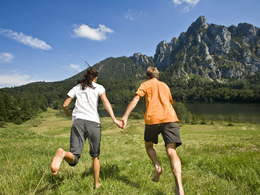
This tour offers impressive views!
This tour offers impressive views!
Starting point: end of the road "Himmelreichstraße"
Destination: Grünberg/lake Laudachsee
")
")
karl_heinz_ruber (8) (© Foto: TVB Traunsee-Almtal/Karl-Heinz Ruber)")
Accessibility / arrival
from the highway: departure Regau-B 145 in the direction of BAd Ischl-through the center of Gmunden-across the bridge "Traunbrücke"-traffic circle first exit-in front of the Gasthof Engelhof turn right till Himmelreichstraße/Grünbergbauer.
Most economical season
- Summer
Please get in touch for more information.
Toscanapark 1
4810 Gmunden
Phone +43 7612 74451
E-Mail info@traunsee-almtal.at
Web www.traunsee-almtal.at
http://www.traunsee-almtal.at
Interactive elevation profile
Create PDF
Tour-Details
Starting place: 4810 Gmunden
Destination: 4810 Gmunden
duration: 1h 39m
length: 4,4 km
Altitude difference (uphill): 319m
Altitude difference (downhill): 62m
Lowest point: 619m
Highest point: 938m
difficulty: difficult
condition: medium
panoramic view: Some Views
Paths covering:
Hiking trail
powered by TOURDATA