

a route to the Attersee


- Flatly
Interactive elevation profile
Create PDF
Tour-Details
Starting place: 4890 Frankenmarkt
Destination: 4890 Frankenmarkt
duration: 5h 0m
length: 55,4 km
Altitude difference (uphill): 548m
Altitude difference (downhill): 548m
Lowest point: 457m
Highest point: 639m
difficulty: medium
condition: medium
panoramic view: Great panorama
Paths covering:
Asphalt
powered by TOURDATA
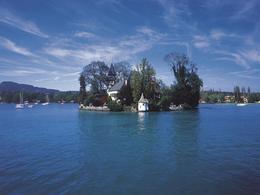
The Attersee Lake, the largest lake in Austria, is the highlight of this circular route.
The starting point is Frankenmarkt where we swing on the bicycle seat and the Salzkammergut Cycle R2 follow up to Attersee. It is the communication path 101, which finally leads us from the banks of the sparkling jewel of Salzkammergut Vöcklamarkt. We then cycle along the R6 Römerradweg back to the starting point.
Route: Frankenmarkt R6 - Attersee R2 - R6 passageway 101 via Lenzing about Vöcklabruck to Frankenmarkt
Accessibility / arrival
by car:
Motorway A1 to St.Georgen im Attergau, turn off to Frankenmarkt
by train:
Westbahn line to Frankenmarkt station
Most economical season
- Spring
- Summer
- Autumn
Please get in touch for more information.
Freistädterstr. 119
4890 Frankenmarkt
Phone +43 7684 6255
E-Mail office@frankenmarkt.at
Web tourismus.frankenmarkt.net
Web attersee-attergau.salzkammergut.at
http://tourismus.frankenmarkt.net
https://attersee-attergau.salzkammergut.at
https://attersee-attergau.salzkammergut.at
Interactive elevation profile
Create PDF
Tour-Details
Starting place: 4890 Frankenmarkt
Destination: 4890 Frankenmarkt
duration: 5h 0m
length: 55,4 km
Altitude difference (uphill): 548m
Altitude difference (downhill): 548m
Lowest point: 457m
Highest point: 639m
difficulty: medium
condition: medium
panoramic view: Great panorama
Paths covering:
Asphalt
powered by TOURDATA