

Taferlklaussee – Hinterer Langbathsee


Interactive elevation profile
Create PDF
Tour-Details
Starting place: 4814 Altmünster
Destination: 4814 Altmünster
duration: 1h 34m
length: 4,4 km
Altitude difference (uphill): 222m
Altitude difference (downhill): 245m
Lowest point: 749m
Highest point: 963m
difficulty: easy
condition: easy
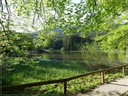
panoramic view: Great panorama
Paths covering:
Hiking trail
powered by TOURDATA
Beautiful tour.except of the Jägersteig it's an easy hike.
From the parking lot Hochleckenaufstieg along forest road to a fork, turn left and follow the forest road up to a bend. At the sign in the steep climb "Jägersteig". The road leads to forest road along this route to 13 and the turning towards the Langbathsee. See the way No. 13.
From the parking lot Hochleckenaufstieg along forest road to a fork, turn left and follow the forest road up to a bend. At the sign in the steep climb "Jägersteig". The road leads to forest road along this route to 13 and the turning towards the Langbathsee. See the way No. 13.
Starting point: parking place Hochlecken
Destination: Hinterer Langbathsee
Accessibility / arrival
departure Regau-B145 in the direction of Bad Ischl-1km after the place name sign "Altmünster"-turn right in the direction ofNeukirchen-Großalmstraße-Taferlklaussee/Hochlecken
Most economical season
- Spring
- Summer
- Autumn
Please get in touch for more information.
4814 Altmünster
Phone +43 7612 87181
E-Mail altmuenster@traunsee.at
Web www.traunsee.at/altmuenster
http://www.traunsee.at/altmuenster
Interactive elevation profile
Create PDF
Tour-Details
Starting place: 4814 Altmünster
Destination: 4814 Altmünster
duration: 1h 34m
length: 4,4 km
Altitude difference (uphill): 222m
Altitude difference (downhill): 245m
Lowest point: 749m
Highest point: 963m
difficulty: easy
condition: easy
panoramic view: Great panorama
Paths covering:
Hiking trail
powered by TOURDATA