

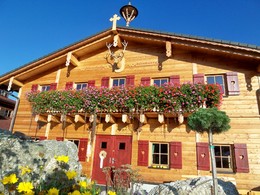
Hirschalmweg Nr. 18


Interactive elevation profile
Create PDF
Tour-Details
Starting place: 4273 Unterweißenbach
Destination: 4273 Unterweißenbach
duration: 1h 30m
length: 3,0 km
Altitude difference (uphill): 230m
Altitude difference (downhill): 238m
Lowest point: 651m
Highest point: 846m
difficulty: medium
condition: medium
panoramic view: Some Views
Paths covering:
Hiking trail
powered by TOURDATA
Hirschalmweg No. 18
This hiking trail takes you past the Wegerer Hof, uphill to the Wegererstein and on via Hinterberg to the Hirschalm fairytale park, which invites you to stop for a bite to eat.
Before returning, you have the opportunity to experience the fairytale trail (length: 1.5 km, walking time: approx. 1.5 hours, particularly suitable for children).
Most economical season
- Spring
- Summer
- Autumn
Please get in touch for more information.
4273 Unterweißenbach
Phone +43 7956 7255
E-Mail marktgemeinde@unterweissenbach.ooe.gv.at
Web www.unterweissenbach.at
http://www.unterweissenbach.at
Interactive elevation profile
Create PDF
Tour-Details
Starting place: 4273 Unterweißenbach
Destination: 4273 Unterweißenbach
duration: 1h 30m
length: 3,0 km
Altitude difference (uphill): 230m
Altitude difference (downhill): 238m
Lowest point: 651m
Highest point: 846m
difficulty: medium
condition: medium
panoramic view: Some Views
Paths covering:
Hiking trail
powered by TOURDATA