

Bergsteinmauer-Hackstock Nr. 28


- Flatly
Interactive elevation profile
Create PDF
Tour-Details
Starting place: 4273 Unterweißenbach
Destination: 4273 Unterweißenbach
duration: 1h 30m
length: 3,0 km
Altitude difference (uphill): 118m
Altitude difference (downhill): 120m
Lowest point: 892m
Highest point: 970m
difficulty: medium
condition: easy
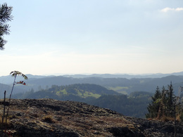
panoramic view: Great panorama
Paths covering:
Hiking trail
powered by TOURDATA
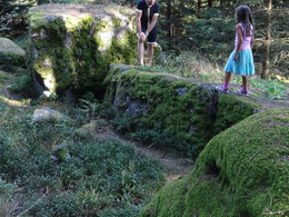
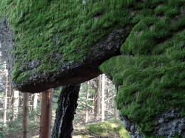
Bergsteinmauer-Hackstock No. 28 - This hike takes you to the highest point of Unterweißenbach, at 990 metres above sea level. The extremely rocky trail offers many attractions, such as the Stations of the Cross, the Small and Large Mountain Stone Wall, the Wobbly Stone and Mini Climbing Route, the "One-Eyed Cyclops Head" boulder and the viewpoint on the Nesselberg. Caution: Children should only be supervised on the rocks!
- Suitable for kids (6 - 10 Year)
- Spring
Please get in touch for more information.
4273 Unterweißenbach
Phone +43 7956 7255
Fax machine +43 7956 7254 - 31
E-Mail marktgemeinde@unterweissenbach.ooe.gv.at
Web www.unterweissenbach.at
http://www.unterweissenbach.at
Interactive elevation profile
Create PDF
Tour-Details
Starting place: 4273 Unterweißenbach
Destination: 4273 Unterweißenbach
duration: 1h 30m
length: 3,0 km
Altitude difference (uphill): 118m
Altitude difference (downhill): 120m
Lowest point: 892m
Highest point: 970m
difficulty: medium
condition: easy
panoramic view: Great panorama
Paths covering:
Hiking trail
powered by TOURDATA