

Burgstallweg


- Flatly
- Possible accommodation
Interactive elevation profile
Create PDF
Tour-Details
Path number: 3
Starting place: 4372 St. Georgen am Walde
Destination: 4372 St. Georgen am Walde
duration: 4h 0m
length: 12,0 km
Altitude difference (uphill): 402m
Altitude difference (downhill): 402m
Lowest point: 692m
Highest point: 949m
difficulty: easy
condition: medium
panoramic view: Dreamtour
Paths covering:
Asphalt, Climbing mount, Hiking trail
powered by TOURDATA
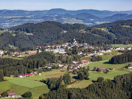
The 949 m high Burgstall is the highest elevation in the district of Perg.
It is located in the eastern part of the municipality of St. Georgen am Walde and forms a steeply sloping hillside to the east, known as the "Graben".
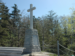
The mountain has always been of great importance to the population, whether it was when the Hussite storms roared through the country or the wild hordes of the French roamed - the castle offered people refuge. It is unclear whether this took place in natural fortifications or whether a castle stood here at the time.
The trail leads from the pavilion eastwards through beautiful forest and meadow paths downhill to the Blümelbach stream, then climbs slightly through the forest to the Burgstall.
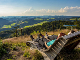
At 949 metres above sea level, it is the highest elevation in the district of Perg. Hikers are rewarded with a marvellous view over the Mühlviertler Alm as far as the Alps. Brave hikers can take the climb through the legendary "Devil's Gorge".
Continue through the forest to the Einsiedelmauer with a view of Dorfstetten, or take the shortcut through the forest. A romantic path leads to the Gebetsberger snack station. After a refreshment stop, you return through the Stieglgraben to Linden and St. Georgen.
It is located in the eastern part of the municipality of St. Georgen am Walde and forms a steeply sloping hillside to the east, known as the "Graben".
The mountain has always been of great importance to the population, whether it was when the Hussite storms roared through the country or the wild hordes of the French roamed - the castle offered people refuge. It is unclear whether this took place in natural fortifications or whether a castle stood here at the time.
The trail leads from the pavilion eastwards through beautiful forest and meadow paths downhill to the Blümelbach stream, then climbs slightly through the forest to the Burgstall.
At 949 metres above sea level, it is the highest elevation in the district of Perg. Hikers are rewarded with a marvellous view over the Mühlviertler Alm as far as the Alps. Brave hikers can take the climb through the legendary "Devil's Gorge".
Continue through the forest to the Einsiedelmauer with a view of Dorfstetten, or take the shortcut through the forest. A romantic path leads to the Gebetsberger snack station. After a refreshment stop, you return through the Stieglgraben to Linden and St. Georgen.
Most economical season
- Spring
- Autumn
Please get in touch for more information.
Markt 9
4372 St. Georgen am Walde
Phone +43 7954 3030 - 20
Fax machine +43 7954 3030 - 30
E-Mail tourismus@st.georgen.at
Web www.st.georgen.at
Web www.oberoesterreich.at/st.georgen.w…
https://www.st.georgen.at
https://www.oberoesterreich.at/st.georgen.walde
https://www.oberoesterreich.at/st.georgen.walde
Interactive elevation profile
Create PDF
Tour-Details
Path number: 3
Starting place: 4372 St. Georgen am Walde
Destination: 4372 St. Georgen am Walde
duration: 4h 0m
length: 12,0 km
Altitude difference (uphill): 402m
Altitude difference (downhill): 402m
Lowest point: 692m
Highest point: 949m
difficulty: easy
condition: medium
panoramic view: Dreamtour
Paths covering:
Asphalt, Climbing mount, Hiking trail
powered by TOURDATA