

Mühlbach-Weg


Interactive elevation profile
Create PDF
Tour-Details
Path number: 2
Starting place: 4372 St. Georgen am Walde
Destination: 4372 St. Georgen am Walde
duration: 3h 30m
length: 13,0 km
Altitude difference (uphill): 323m
Altitude difference (downhill): 323m
Lowest point: 574m
Highest point: 789m
difficulty: easy
condition: medium
panoramic view: Some Views
Paths covering:
Asphalt, Hiking trail
powered by TOURDATA
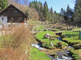
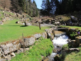
The start is at the pavilion in the village via Jörgenberg downhill through the forest to Vogelsammühle. Here the trail leads along the Vogelsambach stream through meadows and forest paths to the Schreinmühle mill. The romantic path leads past Rumetshofer farms to the Blümelkapelle chapel.
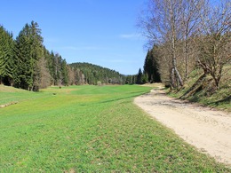
With a slight ascent, the path leads to the Rote-Kreuz and along the Unter St. Georgen goods road to the destination.
With a slight ascent, the path leads to the Rote-Kreuz and along the Unter St. Georgen goods road to the destination.
Most economical season
- Spring
- Autumn
Please get in touch for more information.
Markt 9
4372 St. Georgen am Walde
Phone +43 7954 3030 - 20
Fax machine +43 7954 3030 - 30
E-Mail tourismus@st.georgen.at
Web www.waldreich.at
Web www.oberoesterreich.at/st.georgen.w…
https://www.waldreich.at
https://www.oberoesterreich.at/st.georgen.walde
https://www.oberoesterreich.at/st.georgen.walde
Interactive elevation profile
Create PDF
Tour-Details
Path number: 2
Starting place: 4372 St. Georgen am Walde
Destination: 4372 St. Georgen am Walde
duration: 3h 30m
length: 13,0 km
Altitude difference (uphill): 323m
Altitude difference (downhill): 323m
Lowest point: 574m
Highest point: 789m
difficulty: easy
condition: medium
panoramic view: Some Views
Paths covering:
Asphalt, Hiking trail
powered by TOURDATA