

Vorderstoder- Ramseben - Immerlgsoll


Interactive elevation profile
Create PDF
Tour-Details
Path number: 3,7
Starting place: 4574 Vorderstoder
Destination: 4573 Hinterstoder
duration: 2h 30m
length: 6,6 km
Altitude difference (uphill): 611m
Altitude difference (downhill): 227m
Lowest point: 774m
Highest point: 1.161m
difficulty: easy
condition: easy
panoramic view: Some Views
Paths covering:
Asphalt, Gravel
powered by TOURDATA
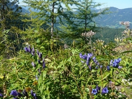
This path offers you fantastic alpine panoramic views from the Haller Mauern, Warscheneck to the Priel mountain ranges. Start from Vorderstoder and turn right at the Country Hotel Stockerwirt to follow the miniature golf hiking trail (sign), pass the Grasseg and Mittermair holiday farms until you reach the small Wurzer farmhouse.
Continue on the Ramseben private road, pass the Family & Country Hotel Lindbichler and the Hubertus chapel to Pension Hinterramseben (1.000 m). This path offers you fantastic alpine panoramic views from the Haller Mauern, Warscheneck to the Priel mountain ranges. From Hinterramseben trail nr. 3 leads over a meadow and briefly through a forest to a forest road, which you follow for about 150 m before turning off to the left. Continue through the forest and a view clearings on an even path to another forest road, leading slightly uphills passing a game feeding station to the Immerlgsoll (1.160 m).
The path to this destination offers stunning views into the Stoder valley and to the nearby Priel mountain range. You can also observe chamoix if you tread softly . The Immerlgsoll is an alpine pasture plateau with a beautiful hunting lodge (not managed). Please take your dogs on a lead (game!).
To return either take the forest road down to the valley and follow trail nr. 7 and then continue along the tar road downhills to the Lögergut farm and on to Vorderstoder, or walk back to Ramseben and continue down to the valley to to Vorderstoder.
Trail-Nr: 3, 7
Starting point: Landhotel Stockerwirt Vorderstoder
Destination: Immerlgsoll Vorderstoder
further information:
- Board possible
")
Accessibility / arrival
by car:
Motorway A1 to A9, exit Voralpenkreuz Hinterstoder, country road to Hinterstoder - 200 meters after the sign turn left to Vorderstoder Hinterstoder (approx 5 km).
by train:
Pyhrnbahn stop Windischgarsten (10 km) or Hinterstoder (15 km) -> from the place
Most economical season
- Summer
Please get in touch for more information.

Vorderstoder 66
4574 Vorderstoder
Phone +43 7564 8255
Fax machine +43 7564 8255 - 20
E-Mail vorderstoder@pyhrn-priel.net
Web www.urlaubsregion-pyhrn-priel.at
http://www.urlaubsregion-pyhrn-priel.at
Interactive elevation profile
Create PDF
Tour-Details
Path number: 3,7
Starting place: 4574 Vorderstoder
Destination: 4573 Hinterstoder
duration: 2h 30m
length: 6,6 km
Altitude difference (uphill): 611m
Altitude difference (downhill): 227m
Lowest point: 774m
Highest point: 1.161m
difficulty: easy
condition: easy
panoramic view: Some Views
Paths covering:
Asphalt, Gravel
powered by TOURDATA