

Rundkurs Greinerschlag


- Flatly
Interactive elevation profile
Create PDF
Tour-Details
Starting place: 4273 Unterweißenbach
Destination: 4273 Unterweißenbach
duration: 2h 15m
length: 8,6 km
Altitude difference (uphill): 97m
Altitude difference (downhill): 90m
Lowest point: 790m
Highest point: 887m
difficulty: easy
condition: easy
panoramic view: Great panorama
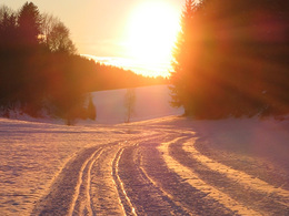
Paths covering:
snow
powered by TOURDATA
Trail not in operation
Circuit Greinerschlag, Unterweißenbach Greinerschlag circuitStart Greinerschlag
10 km length
Most economical season
- Deep winter
Please get in touch for more information.
4273 Unterweißenbach
Phone +43 7956 7255
Fax machine +43 7956 7254 - 37
E-Mail marktgemeinde@unterweissenbach.ooe.gv.at
Web www.unterweissenbach.at
http://www.unterweissenbach.at
Interactive elevation profile
Create PDF
Tour-Details
Starting place: 4273 Unterweißenbach
Destination: 4273 Unterweißenbach
duration: 2h 15m
length: 8,6 km
Altitude difference (uphill): 97m
Altitude difference (downhill): 90m
Lowest point: 790m
Highest point: 887m
difficulty: easy
condition: easy
panoramic view: Great panorama
Paths covering:
snow
powered by TOURDATA