

Wackelsteinweg Nr. 3


- Flatly
- Possible accommodation
Interactive elevation profile
Create PDF
Tour-Details
Starting place: 4280 Königswiesen
Destination: 4280 Königswiesen
duration: 3h 30m
length: 11,5 km
Altitude difference (uphill): 262m
Altitude difference (downhill): 209m
Lowest point: 603m
Highest point: 810m
difficulty: medium
condition: medium
panoramic view: Great panorama
Paths covering:
Hiking trail
powered by TOURDATA
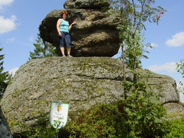
Königswiesen - westwards - Unterweißenbacher Straße - Rumetshofer, Kronbachtal - Pechölstein - Wackelstein (rock block with a particularly small bearing surface - formed by weathering processes, Wollsack weathering, over 1.5 million years ago; with a circumference of 11 metres one of the largest in the Mühlviertel), magnificent view - Schröfhag - Kroneder - Königswiesen
Most economical season
- Summer
Please get in touch for more information.
4280 Königswiesen
Phone +43 7955 6255
Fax machine +43 7955 6255 - 32
E-Mail marktgemeinde@koenigswiesen.at
Web www.koenigswiesen.at
http://www.koenigswiesen.at
Interactive elevation profile
Create PDF
Tour-Details
Starting place: 4280 Königswiesen
Destination: 4280 Königswiesen
duration: 3h 30m
length: 11,5 km
Altitude difference (uphill): 262m
Altitude difference (downhill): 209m
Lowest point: 603m
Highest point: 810m
difficulty: medium
condition: medium
panoramic view: Great panorama
Paths covering:
Hiking trail
powered by TOURDATA