

Senderweg


- pets allowed
- All weather
- Flatly
Interactive elevation profile
Create PDF
Tour-Details
Path number: G1
Starting place: 4264 Grünbach
Destination: 4264 Grünbach
duration: 1h 39m
length: 5,2 km
Altitude difference (uphill): 186m
Altitude difference (downhill): 184m
Lowest point: 717m
Highest point: 858m
difficulty: easy
condition: medium
panoramic view: Great panorama
Paths covering:
Hiking trail
powered by TOURDATA
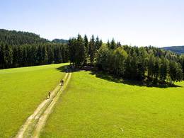
Circular trail with marvellous panoramic views from the Alps across the upper Mühlviertel to southern Bohemia.
The Senderweg begins in the centre of Grünbach. It leads through the village, where the first bench invites you to take a break. From there you have a wonderful view of the village centre, with our beautiful Gothic church.
The hike continues to the Lengauer Höhe, where you can see our neighbouring municipality of Rainbach and, in good weather, have a wonderful view of southern Bohemia.
The trail now leads through a quiet wooded area towards Heinrichschlag, where you walk along the oldest road in Grünbach, the Bierweg! From the Bierweg you can see the village of Prendt and the forests of Windhaag. Then it's up to the transmitter, where you can see the upper village of Grünbach. From there the path leads downhill through the village (approx. 20 min.), where you come directly to the GH Kirchenwirt Seidl.
- All weather
- Suitable for kids (6 - 10 Year)
- Pets allowed
- Spring
Please get in touch for more information.
Marktplatz 1
4264 Grünbach
Phone +43 7942 72813
E-Mail gemeinde@gruenbach.ooe.gv.at
Web www.gruenbach.ooe.gv.at
Web www.muehlviertel-urlaub.at/wandern
http://www.gruenbach.ooe.gv.at
http://www.muehlviertel-urlaub.at/wandern
http://www.muehlviertel-urlaub.at/wandern
Interactive elevation profile
Create PDF
Tour-Details
Path number: G1
Starting place: 4264 Grünbach
Destination: 4264 Grünbach
duration: 1h 39m
length: 5,2 km
Altitude difference (uphill): 186m
Altitude difference (downhill): 184m
Lowest point: 717m
Highest point: 858m
difficulty: easy
condition: medium
panoramic view: Great panorama
Paths covering:
Hiking trail
powered by TOURDATA