

Amusement Park Water Forest Round R1


- pets allowed
- All weather
- Suitable for families
- Suitable for pushchairs
- Flatly
Interactive elevation profile
Create PDF
Tour-Details
Path number: R1
Starting place: 4202 Hellmonsödt
Destination: 4202 Hellmonsödt
duration: 0h 24m
length: 1,6 km
Altitude difference (downhill): 39m
Lowest point: 826m
Highest point: 871m
difficulty: easy
condition: easy
panoramic view: Great panorama
Paths covering:
Asphalt, Gravel, Street
powered by TOURDATA
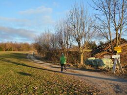
An easy, comfortable walk around the future adventure forest with a beautiful view of Kirchschlag and the mountain range with Dachstein and Großer Priel.
Unfortunately, the former water forest fell victim to the storm Kyrill. The new adventure forest is to be built here next year. Nevertheless, this round is recommended, especially after a meal in one of our recommended restaurants. Starting at the market square, walk in the direction of Reichenau to the schools. Here you turn half right onto path no. 79 (Försterstraße). After approx. 300 m turn left and walk in the direction of the elevated tank. Keeping to the right at the "edge of the forest" you come back to path no. 79. Past the model airfield, go back in the direction of Hellmonsödt. Length: approx. 2km, duration: 3/4 hour
Unfortunately, the former water forest fell victim to the storm Kyrill. The new adventure forest is to be built here next year. Nevertheless, this round is recommended, especially after a meal in one of our recommended restaurants. Starting at the market square, walk in the direction of Reichenau to the schools. Here you turn half right onto path no. 79 (Försterstraße). After approx. 300 m turn left and walk in the direction of the elevated tank. Keeping to the right at the "edge of the forest" you come back to path no. 79. Past the model airfield, go back in the direction of Hellmonsödt. Length: approx. 2km, duration: 3/4 hour
Parking
- Parking space: 100
- Parking area for disabled: 3
- Bus parking space: 3
- All weather
- Suitable for groups
- Suitable for schools
- Suitable for pushchairs
- Pets allowed
- Spring
- Summer
- Autumn
Please get in touch for more information.
Marktplatz 1
4202 Hellmonsödt
Phone +43 7215 2255
E-Mail gemeinde@hellmonsoedt-zwettl.at
Web www.hellmonsoedt.ooe.gv.at/
http://www.hellmonsoedt.ooe.gv.at/
Interactive elevation profile
Create PDF
Tour-Details
Path number: R1
Starting place: 4202 Hellmonsödt
Destination: 4202 Hellmonsödt
duration: 0h 24m
length: 1,6 km
Altitude difference (downhill): 39m
Lowest point: 826m
Highest point: 871m
difficulty: easy
condition: easy
panoramic view: Great panorama
Paths covering:
Asphalt, Gravel, Street
powered by TOURDATA