

Bird walk


Interactive elevation profile
Create PDF
Tour-Details
Starting place: 4682 Geboltskirchen
Destination: 4682 Geboltskirchen
duration: 0h 25m
length: 1,5 km
Altitude difference (uphill): 36m
Altitude difference (downhill): 32m
Lowest point: 604m
Highest point: 636m
Paths covering:
Hiking trail
powered by TOURDATA
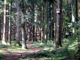
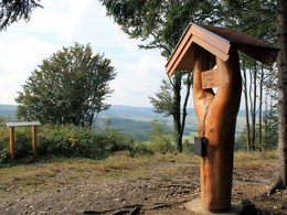
From Scheiben railway station in the direction of Gisela-Stollen and on to the Vogerlweg trail with a wonderful viewing platform: the name "Vogerlweg" comes from the numerous nesting boxes mounted on the trees along the trail. After 15 minutes you cross the Hochweg (810 Ruperti long-distance hiking trail and Hausruck-Kobernaußerwelad long-distance hiking trail). From the signpost "Zum Aussichtsbankerl" you reach the Lederer-Wirtsbankerl after 150 metres with a wonderful view of the course of the Hausruckkamm.
Free hiking map available at the tourist information centres in Bad Schallerbach and Gallspach
Free hiking map available at the tourist information centres in Bad Schallerbach and Gallspach
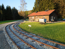
Starting point: Coal station Scheiben, Scheiben 20, 4682 Geboltskirchen
further information:
- Experience of nature
Details - hiking
- themed path
")


Accessibility / arrival
by car:
Motorway:
On the A8 coming from Passau, exit Haag am Hausruck --> approx. 10 km to Geboltskirchen
On the A8 coming from Linz, exit Haag am Hausruck --> approx. 10 km to Geboltskirchen
Bundesstraße:
Coming from Ried im Innkreis or Grieskirchen via the B 141
By train:
Get off at Haag am Hausruck station --> approx. 4 km to Geboltskirchen
for free
- Free entry
Most economical season
- Spring
- Summer
- Autumn
Please get in touch for more information.
Feld 10
4682 Geboltskirchen
Phone +43 7732 3513
E-Mail office@geboltskirchen.at
Web www.geboltskirchen.at
http://www.geboltskirchen.at
Interactive elevation profile
Create PDF
Tour-Details
Starting place: 4682 Geboltskirchen
Destination: 4682 Geboltskirchen
duration: 0h 25m
length: 1,5 km
Altitude difference (uphill): 36m
Altitude difference (downhill): 32m
Lowest point: 604m
Highest point: 636m
Paths covering:
Hiking trail
powered by TOURDATA