

Trattnachtal nature trail


- pets allowed
- Suitable for families
- Suitable for pushchairs
- Suitable for kids (all ages)
Interactive elevation profile
Create PDF
Tour-Details
Starting place: 4702 Wallern an der Trattnach
Destination: 4702 Wallern an der Trattnach
duration: 0h 15m
length: 1,0 km
Altitude difference (uphill): 9m
Altitude difference (downhill): 12m
Lowest point: 294m
Highest point: 307m
difficulty: very easy
condition: very easy
panoramic view: Individual Views
Paths covering:
Gravel, Other
powered by TOURDATA
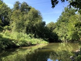
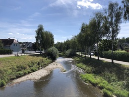
The Trattnachtal nature trail leads along the Trattnach River from Wallern to Bad Schallerbach and in an easterly direction to Brucknerstraße. The path is about 2 km long, level and very well developed. 22 information boards at eleven stations, most of which are equipped with benches and tables, provide an insight into the diversity of the beautiful Trattnachtal and the market town of Wallern.
Free hiking map available at the Tourist-Infos Bad Schallerbach and Gallspach
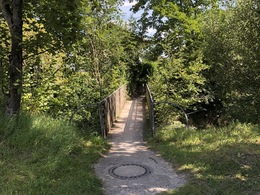
The hike starts at the Trattnach bridge near the town center. The children and parents hike from Wallern along the Trattnach River to Bad Schallerbach. Thanks to the lighting, the Trattnachtal nature trail is also inviting for an evening walk.
The Trattnachtal Nature Trail in the municipal area of Wallern provides information about the ecological relationships and the regional flora and fauna. When children and parents hike along the 2.5 km long Trattnachtal nature trail in Wallern, 22 display boards at 11 stations provide interesting information. On this hiking trail the ecological connections are explained as well as information about the animal and plant world of the region. For example, the children learn that the kingfisher has its habitat here and that the Trattnach is populated by brown and rainbow trout.
Interesting stations
The already existing Trattnachtal Nature Trail was redesigned in 2000 and made even more attractive. The stations, which give an insight into the diversity of the Trattnachtal, are mostly equipped with resting benches and tables, which invite you to linger and have a leisurely snack.
Free hiking map available at the Tourist-Infos Bad Schallerbach and Gallspach
Free rental of Nordic Walking sticks at the Tourist-Info Bad Schallerbach
The hike starts at the Trattnach bridge near the town center. The children and parents hike from Wallern along the Trattnach River to Bad Schallerbach. Thanks to the lighting, the Trattnachtal nature trail is also inviting for an evening walk.
The Trattnachtal Nature Trail in the municipal area of Wallern provides information about the ecological relationships and the regional flora and fauna. When children and parents hike along the 2.5 km long Trattnachtal nature trail in Wallern, 22 display boards at 11 stations provide interesting information. On this hiking trail the ecological connections are explained as well as information about the animal and plant world of the region. For example, the children learn that the kingfisher has its habitat here and that the Trattnach is populated by brown and rainbow trout.
Interesting stations
The already existing Trattnachtal Nature Trail was redesigned in 2000 and made even more attractive. The stations, which give an insight into the diversity of the Trattnachtal, are mostly equipped with resting benches and tables, which invite you to linger and have a leisurely snack.
Starting point: Mitterweg (sedda company)
Destination: Trattnachsteg (Trattnachstraße)
further information:
- Experience of nature
Details - hiking
- educational path
Start
Ziel


Accessibility / arrival
by car:
On the A8 coming from Passau, exit Pichl --> continue on the federal road B134 to Wallern.
On the A8 coming from Linz, exit Pichl --> continue on the federal road B134 to Wallern
by train:
The train station Bad Schallerbach-Wallern is 2 km away from the village.
- Parking space: 204
free of charge
- Free entry
- Suitable for groups
- Suitable for schools
- Suitable for kids (all ages)
- Suitable for pushchairs
- Pets allowed
- Suitable for teenagers
- Suitable for seniors
- Suitable for single travelers
- Suitable for friends
- Suitable for children
- Spring
- Summer
- Autumn
- Early winter
Somewhat suitable for wheelchairs: Assistance is sometimes necessary. The measurements do not (fully) conform to the legally stipulated ÖNORM.
Marktplatz 1
4702 Wallern an der Trattnach
Phone +43 7249 42071
Fax machine +43 7249 42071 - 13
E-Mail gemeinde@wallern.ooe.gv.at
Web www.wallern.ooe.gv.at/
http://www.wallern.ooe.gv.at/
Interactive elevation profile
Create PDF
Tour-Details
Starting place: 4702 Wallern an der Trattnach
Destination: 4702 Wallern an der Trattnach
duration: 0h 15m
length: 1,0 km
Altitude difference (uphill): 9m
Altitude difference (downhill): 12m
Lowest point: 294m
Highest point: 307m
difficulty: very easy
condition: very easy
panoramic view: Individual Views
Paths covering:
Gravel, Other
powered by TOURDATA