

Bärenlucke S6


- Suitable for families
- Flatly
Interactive elevation profile
Create PDF
Tour-Details
Path number: S6
Starting place: 4364 St. Thomas am Blasenstein
Destination: 4364 St. Thomas am Blasenstein
duration: 1h 48m
length: 5,6 km
Altitude difference (uphill): 209m
Altitude difference (downhill): 217m
Lowest point: 609m
Highest point: 731m
difficulty: medium
condition: medium
panoramic view: Some Views
Paths covering:
Asphalt, Gravel, unfixed, Hiking trail
powered by TOURDATA
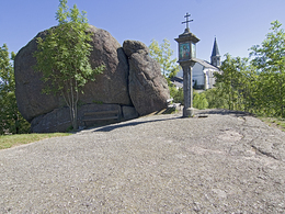
Hike around the village. Standing in front of the launch site with a view of the church, turn right between two houses towards Bergweg. Descend to the Blasensteiner Landesstraße, cross it and enter the settlement Am Sonnenhang. Continue on a beautiful flat forest path to the access road to the Guger seminar house. Continue right past the Wasserhaus, cross the Klausbach stream and turn right uphill. Once you reach the Mitter St. Thomas estate road, turn right and immediately left again up to the Franzlsteiner farmhouse. After the house, turn left and up into the forest. On the plateau through woods then down to the houses Mitter St. Thomas 4 and 5. After their driveway, immediately turn right back into the forest. Opposite the forest anthill, ascend into the forest to the Bärenlucke. To the left of the rock formation, continue through the forest to the Staub goods road. There, take a short left on the goods road to the Klingenberg country road. Follow this road briefly and then cross it, turning right to the Ploama access road. Shortly before the house, turn left into the forest. Through the forest and left downhill to the clubhouse of the gymnastics and sports union and tennis centre. Follow the pavement along the road to the fire station. There you can visit the Phallus stone off the path. Return to the village on the footpath.
- Suitable for groups
- Suitable for schools
- Suitable for friends
- Suitable for couples
- Suitable for children
- Spring
- Summer
- Autumn
Please get in touch for more information.
Markt 7
4364 St. Thomas am Blasenstein
Phone +43 7265 5455
E-Mail marktgemeinde@st-thomas.at
Web www.st-thomas.at/
https://www.st-thomas.at/
Interactive elevation profile
Create PDF
Tour-Details
Path number: S6
Starting place: 4364 St. Thomas am Blasenstein
Destination: 4364 St. Thomas am Blasenstein
duration: 1h 48m
length: 5,6 km
Altitude difference (uphill): 209m
Altitude difference (downhill): 217m
Lowest point: 609m
Highest point: 731m
difficulty: medium
condition: medium
panoramic view: Some Views
Paths covering:
Asphalt, Gravel, unfixed, Hiking trail
powered by TOURDATA