

352 Cycle tour "Steyrtalblick"


- Suitable for families
- culinary interesting
- Flatly
Interactive elevation profile
Create PDF
Tour-Details
Path number: 352
Starting place: 4540 Bad Hall
Destination: 4540 Bad Hall
duration: 2h 0m
length: 19,0 km
Altitude difference (uphill): 210m
difficulty: easy
condition: easy
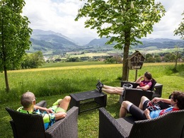
panoramic view: Great panorama
Paths covering:
Asphalt
powered by TOURDATA
Cycle route on quiet side roads without any significant gradients, also suitable for the untrained.
The Steyr is a real mountain river - but we stay in the foothills of the Alps and view the valley from a reasonable distance.
In St. Blasien, a gentle ascent begins on quiet goods roads with magnificent views from the Traunstein in the west to the Damberg in the east. Another short stretch of "mountain road" and we end up just above Waldneukirchen, looking left into the Danube valley, with the Steyr hidden behind the first hills on the right.
We roll comfortably into the "feel-good community" of Waldneukirchen, which has been settled for more than 900 years and today boasts a thriving economy. Waldneukirchen lies on a plate above the Steyr - the rugged limestone peaks have already given way to gentle elevations. From the Steinersdorf goods road, we have a view of almost the entire Steyr valley from its source in the Totes Gebirge to its mouth in the iron town of Steyr ... we don't see the river itself today, as it likes to bury itself deep in ice-age conglomerate gorges. The atmosphere is nevertheless a joy - we marvel at house chapels created by a local master and remember at the Steinersdorf fire station that threats are always present; the water of the Steyr is also life or destruction at the same time.
Path:
Eduard-Bach-Straße - St. Blasien - Waldneukirchen - Güterweg Steinersdorf - Steinersdorf fire station - Eduard-Bach-Straße.
Our lovely blogger Angelika Mandler-Saul has written a wonderful report about our cycling region, which you can read here!
- Suitable for groups
- Suitable for schools
- Spring
- Summer
- Autumn
Please get in touch for more information.
Kurpromenade 1
4540 Bad Hall
Phone +43 7258 7200
Fax machine +43 7258 7200 - 20
E-Mail info@badhall.at
Web www.badhall.at
http://www.badhall.at
Interactive elevation profile
Create PDF
Tour-Details
Path number: 352
Starting place: 4540 Bad Hall
Destination: 4540 Bad Hall
duration: 2h 0m
length: 19,0 km
Altitude difference (uphill): 210m
difficulty: easy
condition: easy
panoramic view: Great panorama
Paths covering:
Asphalt
powered by TOURDATA