

Opferschalenweg Wimberg - Mühlberg Nr. 02


- Suitable for families
- Suitable for kids (all ages)
- Flatly
- Possible accommodation
Interactive elevation profile
Create PDF
Tour-Details
Starting place: 4294 St. Leonhard bei Freistadt
Destination: 4294 St. Leonhard bei Freistadt
duration: 1h 45m
length: 4,4 km
Altitude difference (uphill): 474m
Altitude difference (downhill): 472m
Lowest point: 645m
Highest point: 833m
difficulty: easy
condition: easy
panoramic view: Some Views
Paths covering:
Asphalt, Hiking trail
powered by TOURDATA
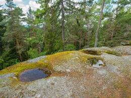
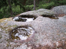
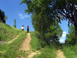
This circular hiking trail takes you to the partly dry and partly watery sacrificial bowls on the Wimberg and Mühlberg and is easy to walk for young and old. A small playground has been created for young hikers at the marvellous viewing point on the Mühlberg. A new wooden bridge has been built to reach the Opferschalenstein on the Mühlberg. A number of benches and wooden chairs along the route invite you to take a break. Enjoy the wonderful views of our beautiful village, the Predigtberg with the Susi Wallner lookout point and the Herzogreitherfelsen rock. Here you have a marvellous panoramic view over the hilly landscape of the Mühlviertel as far as the Alps. This hiking trail is easily accessible for young and old.
Refreshment stops in the village centre - GH Schwarz (closed on Mondays), GH Janko (closed on Tuesdays and Mondays), Cafe Konditorei Honeder
Refreshment stops in the village centre - GH Schwarz (closed on Mondays), GH Janko (closed on Tuesdays and Mondays), Cafe Konditorei Honeder
further information:
- Flatly
- Possible accommodation
- Board possible
Details - hiking
- themed path
- Suitable for groups
- Suitable for kids (all ages)
- Suitable for seniors
- Suitable for single travelers
- Suitable for friends
- Suitable for couples
- Suitable for children
- Spring
Please get in touch for more information.
Hauptstraße 9
4294 St. Leonhard bei Freistadt
Phone +43 7952 8255
E-Mail gemeinde@st-leonhard.ooe.gv.at
Web www.stleonhard.at
http://www.stleonhard.at
Interactive elevation profile
Create PDF
Tour-Details
Starting place: 4294 St. Leonhard bei Freistadt
Destination: 4294 St. Leonhard bei Freistadt
duration: 1h 45m
length: 4,4 km
Altitude difference (uphill): 474m
Altitude difference (downhill): 472m
Lowest point: 645m
Highest point: 833m
difficulty: easy
condition: easy
panoramic view: Some Views
Paths covering:
Asphalt, Hiking trail
powered by TOURDATA