

Naarntal-Erlebnisweg Nr. 82


- Suitable for families
- Flatly
- Possible accommodation
Interactive elevation profile
Create PDF
Tour-Details
Starting place: 4274 Schönau im Mühlkreis
Destination: 4274 Schönau im Mühlkreis
duration: 3h 0m
length: 12,0 km
Altitude difference (uphill): 345m
Altitude difference (downhill): 339m
Lowest point: 521m
Highest point: 733m
difficulty: easy
condition: easy
panoramic view: Some Views
Paths covering:
Asphalt, Gravel, Hiking trail
powered by TOURDATA
The village of Schönau im Mühlkreis lies between Waldaist and Naarn amidst densely wooded hilltops, which are also ideal for hiking. The townscape is characterised by many original farmhouses with their bare stone walls. From the hill of the "Hergottsitz" (allegedly an early Christian place of worship and sacrifice), there is a magnificent panoramic view, which on clear days makes the Alps seem close enough to touch.
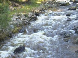
After the start, you hike via the Hofinger Chapel and through the so-called Spielreith, soon after which you reach the small Naarn. Upstream you walk through a wild and romantic valley to the ruins of the Apostelmühle mill. This once belonged to 12 farmers from the area around Mötlas, hence the name. The mill was still in operation until the early 1950s. You then cross the Naarn and walk through the typical Mühlviertel cultural landscape past the Pferdeschwemme to the Gstöttner riding park. Continue past the deer park to the "Schmallehner", a Mühlviertel farmhouse that has been almost completely preserved in its original state. From there, you can enjoy a leisurely hike back down to Schönau.
After the start, you hike via the Hofinger Chapel and through the so-called Spielreith, soon after which you reach the small Naarn. Upstream you walk through a wild and romantic valley to the ruins of the Apostelmühle mill. This once belonged to 12 farmers from the area around Mötlas, hence the name. The mill was still in operation until the early 1950s. You then cross the Naarn and walk through the typical Mühlviertel cultural landscape past the Pferdeschwemme to the Gstöttner riding park. Continue past the deer park to the "Schmallehner", a Mühlviertel farmhouse that has been almost completely preserved in its original state. From there, you can enjoy a leisurely hike back down to Schönau.
Most economical season
- Spring
Please get in touch for more information.
Schulstraße 1
4274 Schönau im Mühlkreis
Phone +43 7261 7255
E-Mail gemeinde@schoenau-im.at
Web www.schoenau-im.at
http://www.schoenau-im.at
Interactive elevation profile
Create PDF
Tour-Details
Starting place: 4274 Schönau im Mühlkreis
Destination: 4274 Schönau im Mühlkreis
duration: 3h 0m
length: 12,0 km
Altitude difference (uphill): 345m
Altitude difference (downhill): 339m
Lowest point: 521m
Highest point: 733m
difficulty: easy
condition: easy
panoramic view: Some Views
Paths covering:
Asphalt, Gravel, Hiking trail
powered by TOURDATA