

Ruttensteinweg


- All weather
- culturally interesting
- Flatly
- Possible accommodation
Interactive elevation profile
Create PDF
Tour-Details
Path number: Nr. 95
Starting place: 4282 Pierbach
Destination: 4282 Pierbach
duration: 3h 0m
length: 12,0 km
Altitude difference (uphill): 522m
Altitude difference (downhill): 518m
Lowest point: 493m
Highest point: 757m
difficulty: easy
condition: medium
panoramic view: Dreamtour
Paths covering:
Hiking trail
powered by TOURDATA
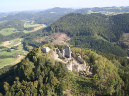
Ruttensteinweg No. 95 - The Ruttenstein castle ruins are one of the mightiest fortified castles in Austria. The view from the well-preserved residential tower is magnificent and, in good weather, extends from the beautiful Mühlviertel hills to the Dachstein.
Leaving the village and following the Große Naarn for a short distance, the route leads uphill via a narrow footbridge to the "Hörzinghofer-Kreuz". From there, the trail continues gently uphill towards the Ruttenstein ruins. In good weather, the well-preserved tower of the ruins offers a magnificent view far into the countryside. Now it's downhill. The way back leads through marvellous forests down to the power station on the Große Naarn. The route leads along the water back to Pierbach.
More information about the castle: www.ruttenstein.at
- All weather
- Suitable for kids (3 - 14 Year)
- Summer
Please get in touch for more information.
Dorfstraße 22
4282 Pierbach
Phone +43 7267 8255
Fax machine +43 7267 8255 - 14
E-Mail gemeinde@pierbach.ooe.gv.at
Web www.pierbach.at
http://www.pierbach.at
Interactive elevation profile
Create PDF
Tour-Details
Path number: Nr. 95
Starting place: 4282 Pierbach
Destination: 4282 Pierbach
duration: 3h 0m
length: 12,0 km
Altitude difference (uphill): 522m
Altitude difference (downhill): 518m
Lowest point: 493m
Highest point: 757m
difficulty: easy
condition: medium
panoramic view: Dreamtour
Paths covering:
Hiking trail
powered by TOURDATA