Klaffer am Hochficht Chapel Trail
Path number: 24
Starting place: 4163 Klaffer am Hochficht
Destination: 4163 Klaffer am Hochficht
Beautiful easy hike in the herbal community of Klaffer am Hochficht in the enchanting Böhmerwald holiday region!
490 m herb garden. After approx. 100 metres, you will see the Pechölstein on the right-hand side of the Sonnenweg. Turn right and walk along the southern slope of Klaffer to Mühltalweg. Continue left here. Now a field path begins, which turns into a forest path. You walk through the short section of forest and the romantic river "Große Mühl" accompanies you
2.2 km When you reach the tarmac road, leave the Sagenweg and continue left. Leave the Vorderanger bridge on your left. In Vorderanger, walk straight ahead at the lamp post onto the meadow path, which shortly afterwards rejoins the tarmac road. Take the path on the left here and walk past the houses towards the forest. Immediately afterwards, you will pass the ...
3.7 km Ash Chapel. This chapel was built in 1701 by the Ascher family out of gratitude. Having fled to Germany during the Peasants' War, the family was able to return after the end of the war. The chapel was renovated in 1983-85. Shortly afterwards, take the right fork in the road. The half-marathon route, which accompanied us briefly, branches off to the left here. At the road you reach immediately afterwards, which leads to Breitenberg (DE), continue left and shortly afterwards turn right again towards Hinteranger. In the distance you will see the ...
5.4 km village of Panidorf, which you approach by turning right. The unusual village layout of Panidorf is immediately noticeable when you look at the place. Joseph Pany (1790-1850), son of a Bohemian teacher and clerk and court clerk of Schlägl Abbey, created a monument to himself by building this village. Between 1827 and 1835, he built this workers' housing estate with 26 houses, all small semi-detached or terraced houses. Once you reach the Dreisesselbergstraße Schwarzenberg-Klaffer, turn right and walk for approx. 600 metres. Visit the ...
6.2 km Tonin Chapel, just a few metres away. The exact year of construction is unknown. The first written reference is dated 29 September 1873. The beautiful wrought-iron roof cross suggests that the chapel was built by Schlägl Abbey. You walk back the few metres and follow the signs for Schönberg and Russenstein. The hiking trail leads you uphill to the scattered Schönberg houses. The hike now reaches its westernmost turning point and the path loops back to Klaffer. Marvellous views of Klaffer and the Mühltal valley open up before your eyes. Before the road leads downhill again, leave it at the edge of the forest and turn left into the forest. This is where the Fleischhackerberg forest road begins. After the barrier you will overlook the turn-off to the right downhill to the ...
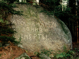
8.0 km Russenstein A Russian soldier carved "Death to the organiser of the war" in Cyrillic on the stone. After the memorial, the forest path leads steeply uphill for a short distance to the forest road. Continue right here. This leads out of the forest. Continue your hike along a beautiful country lane, with Klaffer already in sight. Parallel to the path of deceleration, always follow the signs
10.2 km Before the sports field, the hiking trail turns right along the fence into the meadow path. In the hollow, you pass a pond before the path leads you uphill back to the starting point...
<
11.0 km
Request our hiking map for EUR 3.00!
With the free app outdooractive you can hike the trail by navigation.
Path number: 24
Starting place: 4163 Klaffer am Hochficht
Destination: 4163 Klaffer am Hochficht
duration: 3h 30m
length: 11,0 km
Altitude difference (uphill): 230m
Altitude difference (downhill): 234m
Lowest point: 593m
Highest point: 720m
difficulty: medium
condition: medium
panoramic view: Great panorama
Paths covering:
Asphalt, Gravel, Hiking trail
Starting point: Klaffer am Hochficht village centre, parking spaces at the municipal office.
Destination: Klaffer am Hochficht village centre, parking spaces at the municipal office.
further information:
- Flatly
- Possible accommodation
- Board possible
Details - hiking
- themed path
Most economical season
- Spring
- Summer
- Autumn
Please get in touch for more information.
Dorfplatz 1
4163 Klaffer am Hochficht
Phone +43 5 07263 - 200
E-Mail boehmerwald@muehlviertel.at
Web www.muehlviertel.at/
https://www.muehlviertel.at/
You can also visit us on
Facebook Twitter / X Instagram YouTube Documents:


