

O6 St. Oswalder - Höhenweg


- Flatly
Interactive elevation profile
Create PDF
Tour-Details
Path number: O6
Starting place: 4271 St. Oswald bei Freistadt
Destination: 4271 St. Oswald bei Freistadt
duration: 7h 49m
length: 25,3 km
Altitude difference (uphill): 790m
Altitude difference (downhill): 792m
Lowest point: 603m
Highest point: 950m
difficulty: medium
condition: medium
panoramic view: Individual Views
Paths covering:
Hiking trail
powered by TOURDATA
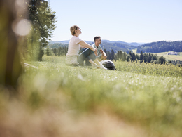
St. Oswald is the golfing community in the Mühlviertel. Old forests, meadows and pastures line the golf course. Immerse yourself in the beautiful nature along the high-altitude trail in St. Oswald near Freistadt at an altitude of between 800 m and 950 m above sea level.
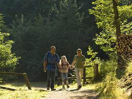
The hiking trail starts at the municipal office and runs towards the old sports field. The trail leads to the Braunberg via the viewpoint at the "Hasenecker". From there you can enjoy a magnificent view and the Alpine Club hut offers refreshments from 1 April to 31 October. The hiking trail leads via the villages of Witzelsberg and Stiftungsberg to the very impressive Raphaelshöhe viewpoint. From there, the trail continues to the villages of Untermarreith and Obermarreith, where the Dorfwirtshaus Gartner offers the opportunity for refreshments. The next wonderful vantage point is St. Michael with its pilgrimage church at 918 metres above sea level. The church is also located exactly on the watershed of the two European river systems of the Danube and Vltava/Elbe. Via Oberrauchenödt, the Rannahof youth hostel, Etzelsdorf and past the Funiversum Trenda, you return to the starting point of the hike.
The hiking trail starts at the municipal office and runs towards the old sports field. The trail leads to the Braunberg via the viewpoint at the "Hasenecker". From there you can enjoy a magnificent view and the Alpine Club hut offers refreshments from 1 April to 31 October. The hiking trail leads via the villages of Witzelsberg and Stiftungsberg to the very impressive Raphaelshöhe viewpoint. From there, the trail continues to the villages of Untermarreith and Obermarreith, where the Dorfwirtshaus Gartner offers the opportunity for refreshments. The next wonderful vantage point is St. Michael with its pilgrimage church at 918 metres above sea level. The church is also located exactly on the watershed of the two European river systems of the Danube and Vltava/Elbe. Via Oberrauchenödt, the Rannahof youth hostel, Etzelsdorf and past the Funiversum Trenda, you return to the starting point of the hike.
- Suitable for groups
- Suitable for seniors
- Suitable for single travelers
- Suitable for friends
- Suitable for couples
- Spring
- Summer
- Autumn
- Early winter
Please get in touch for more information.
Markt 80
4271 St. Oswald bei Freistadt
Phone +43 7945 7255
E-Mail gemeinde@stoswald.at
Web www.stoswald.at
Web www.muehlviertel-urlaub.at/wandern
http://www.stoswald.at
http://www.muehlviertel-urlaub.at/wandern
http://www.muehlviertel-urlaub.at/wandern
")
")

")
")
Interactive elevation profile
Create PDF
Tour-Details
Path number: O6
Starting place: 4271 St. Oswald bei Freistadt
Destination: 4271 St. Oswald bei Freistadt
duration: 7h 49m
length: 25,3 km
Altitude difference (uphill): 790m
Altitude difference (downhill): 792m
Lowest point: 603m
Highest point: 950m
difficulty: medium
condition: medium
panoramic view: Individual Views
Paths covering:
Hiking trail
powered by TOURDATA