

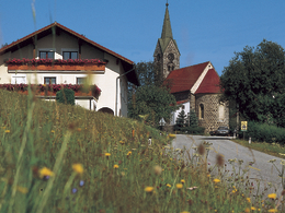
Stadl-Route


- Flatly
Interactive elevation profile
Create PDF
Tour-Details
Path number: 4 - Reitweg
Starting place: 4090 Engelhartszell
Destination: 4090 Engelhartszell
duration: 0h 54m
length: 3,2 km
Altitude difference (uphill): 57m
Altitude difference (downhill): 63m
Lowest point: 657m
Highest point: 725m
difficulty: easy
condition: easy
panoramic view: Individual Views
Paths covering:
Asphalt
powered by TOURDATA
The Stadl route has the path number 4. Starting point is the church in Stadl - continue in the direction of Engelhartszell - turn right to the Thomandl snack station - continue along the edge of the forest to the main road - cross over - up to Berg to the main road - turn right - past the riding centre - turn left onto Wiesenweg - up to the houses in Flenkental - turn right back to the main road - turn right again and then left to the trout circus in Mühlbach. Continue to Schöfberg, Edt and back to Stadl.
further information:
- Flatly
Details riding
- Area: easy
- Good riding experience: easy
- Suitable for kids (6 - 10 Year)
- Suitable for single travelers
- Suitable for friends
- Suitable for couples
- Spring
- Summer
- Autumn
- Early winter
Please get in touch for more information.
Martkplatz 61
4090 Engelhartszell
Phone +43 7717 8055 - 16
E-Mail tourismus@engelhartszell.ooe.gv.at
Web www.engelhartszell.at
https://www.engelhartszell.at
Interactive elevation profile
Create PDF
Tour-Details
Path number: 4 - Reitweg
Starting place: 4090 Engelhartszell
Destination: 4090 Engelhartszell
duration: 0h 54m
length: 3,2 km
Altitude difference (uphill): 57m
Altitude difference (downhill): 63m
Lowest point: 657m
Highest point: 725m
difficulty: easy
condition: easy
panoramic view: Individual Views
Paths covering:
Asphalt
powered by TOURDATA