

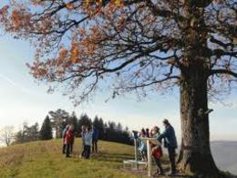
Höhen-Wanderung


- Flatly
Interactive elevation profile
Create PDF
Tour-Details
Path number: 6 - Wanderweg
Starting place: 4725 St. Aegidi
Destination: 4725 St. Aegidi
duration: 2h 15m
length: 8,4 km
Altitude difference (uphill): 114m
Altitude difference (downhill): 118m
Lowest point: 583m
Highest point: 722m
difficulty: easy
condition: medium
panoramic view: No view
Paths covering:
Asphalt
powered by TOURDATA
This hiking trail has the trail number 6 The hiking route runs entirely on paved and little-used goods roads. From the village of St. Aegidi, the hike follows pavements in the direction of Kellerwirt. There we cross the Sauwaldstraße, follow the pavement in the direction of Schärding and after a short stretch turn right onto the Reiting goods road. Through woods, over the Perlbach stream and past meadows, the goods track leads uphill through the village of Reiting past farmhouses.
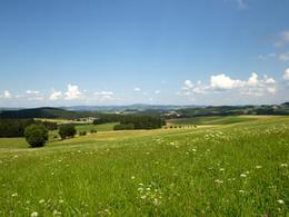
Passing Neuhofen on the right, we are rewarded for the ascent with a marvellous view of the Mühlviertel after a section of forest.
The route leads back downhill to the right along the Schöfberg goods road. Once in Schöfberg, continue right via Zimmerleiten past the village chapel back in the direction of St. Aegidi.
Most economical season
- Spring
- Summer
- Autumn
Please get in touch for more information.
St. Aegidi 10
4725 St. Aegidi
Phone +43 7717 7355 - 0
Fax machine +43 7717 7355 - 4
E-Mail gemeinde@st-aegidi.ooe.gv.at
Web www.st-aegidi.at
http://www.st-aegidi.at
Interactive elevation profile
Create PDF
Tour-Details
Path number: 6 - Wanderweg
Starting place: 4725 St. Aegidi
Destination: 4725 St. Aegidi
duration: 2h 15m
length: 8,4 km
Altitude difference (uphill): 114m
Altitude difference (downhill): 118m
Lowest point: 583m
Highest point: 722m
difficulty: easy
condition: medium
panoramic view: No view
Paths covering:
Asphalt
powered by TOURDATA