

Donaunixe-Isa-Wanderung


- Flatly
Interactive elevation profile
Create PDF
Tour-Details
Path number: 1 - Wanderweg
Starting place: 4090 Engelhartszell
Destination: 4090 Engelhartszell
duration: 1h 24m
length: 4,2 km
Altitude difference (uphill): 176m
Altitude difference (downhill): 178m
Lowest point: 279m
Highest point: 455m
difficulty: easy
condition: easy
panoramic view: Individual Views
Paths covering:
Asphalt
powered by TOURDATA
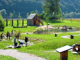
The Donaunixe Isa hike has trail number 1. The tour through the Engelhartstzell Danube World begins at Engelszell Abbey. The first stops are the "Engelszell Sensory Garden" and the "Mini-Danube Water Experience" - well worth the entrance fee! Open: May to September, daily from 1 to 5 pm.
Ask for the info folder: Tel. +43 (0) 7717/8055-16
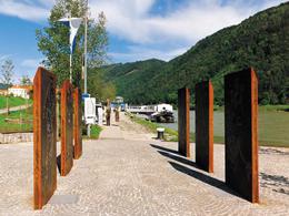
Continue down to the Danube and along the Danube Trail to the "Danube Studios" of local artists. The turbine of the "Donau-Platz" is impressive and the exhibition in the "Donau-Schiff" is interesting. Above the square is the "Donau-Spiel" adventure playground and the "Donau-Geschichten" exhibition. Past the flood tree and the "Überfuhrhäusl", a path along the Danube leads to the Fallauerbach stream, the "Wet State Border", on to the Roman milestone and the Jochenstein Danube power station. If you want, you can make a detour to the German side to the "Haus am Srom".
Then head up to the "Jausenstation Bernhard" on the Austrian side and continue along a forest path back to Engelhartszell.
Ask for the info folder: Tel. +43 (0) 7717/8055-16
Continue down to the Danube and along the Danube Trail to the "Danube Studios" of local artists. The turbine of the "Donau-Platz" is impressive and the exhibition in the "Donau-Schiff" is interesting. Above the square is the "Donau-Spiel" adventure playground and the "Donau-Geschichten" exhibition. Past the flood tree and the "Überfuhrhäusl", a path along the Danube leads to the Fallauerbach stream, the "Wet State Border", on to the Roman milestone and the Jochenstein Danube power station. If you want, you can make a detour to the German side to the "Haus am Srom".
Then head up to the "Jausenstation Bernhard" on the Austrian side and continue along a forest path back to Engelhartszell.
further information:
- Flatly
Details - hiking
- themed path
- educational path
Most economical season
- Spring
- Summer
- Autumn
Please get in touch for more information.
Marktplatz 61
4090 Engelhartszell
Phone +43 7717 8055 - 16
E-Mail tourismus@engelhartszell.ooe.gv.at
Web www.engelhartszell.at
https://www.engelhartszell.at
Interactive elevation profile
Create PDF
Tour-Details
Path number: 1 - Wanderweg
Starting place: 4090 Engelhartszell
Destination: 4090 Engelhartszell
duration: 1h 24m
length: 4,2 km
Altitude difference (uphill): 176m
Altitude difference (downhill): 178m
Lowest point: 279m
Highest point: 455m
difficulty: easy
condition: easy
panoramic view: Individual Views
Paths covering:
Asphalt
powered by TOURDATA