© Photo: Oberösterreich Tourismus GmbH./Robert Maybach: Enjoy the view in Upper Austria


KULTURWEG | Bewegungs-Arena INNVIERTEL


- Suitable for families
- culturally interesting
- Flatly
Interactive elevation profile
Create PDF
Tour-Details
Path number: Nr. 4
Starting place: 4925 Pramet
Destination: 4925 Pramet
duration: 2h 31m
length: 9,2 km
Altitude difference (uphill): 148m
Altitude difference (downhill): 148m
Lowest point: 508m
Highest point: 624m
difficulty: medium
condition: medium
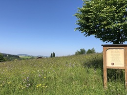
panoramic view: Great panorama
Paths covering:
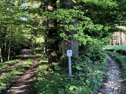
Hiking trail
powered by TOURDATA
The municipality of Pramet has dedicated a culture trail with numerous poetry panels to its three dialect poets Franz Stelzhamer, Hans Schatzdorfer and Ferdinand Binder.
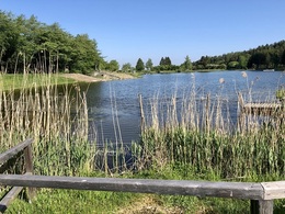
After arriving at the bathing lake, the trail follows the edge of the Hausruck forest for a bit, from where you get a beautiful view of the lake and its inn. Return via Lungdorf along a meadow path to the village center.
further information:
- Flatly
Details - hiking
- themed path
- Suitable for groups
- Suitable for schools
- Suitable for teenagers
- Suitable for single travelers
- Suitable for families
- Suitable for friends
- Suitable for couples
- Spring
- Summer
- Autumn
- Early winter
Please get in touch for more information.
4925 Pramet
Phone +43 7754 8450
Fax machine +43 7754 8450 - 22
E-Mail gemeinde@pramet.ooe.gv.at
Web www.pramet.at/system/web/default.as…
https://www.pramet.at/system/web/default.aspx?sprache=1
You can also visit us on
Visit us on Facebook")
")
")
")

Interactive elevation profile
Create PDF
Tour-Details
Path number: Nr. 4
Starting place: 4925 Pramet
Destination: 4925 Pramet
duration: 2h 31m
length: 9,2 km
Altitude difference (uphill): 148m
Altitude difference (downhill): 148m
Lowest point: 508m
Highest point: 624m
difficulty: medium
condition: medium
panoramic view: Great panorama
Paths covering:
Hiking trail
powered by TOURDATA