

Fir tree circular walk


- Suitable for kids (all ages)
- Flatly
Interactive elevation profile
Create PDF
Tour-Details
Starting place: 5310 Tiefgraben am Mondsee
Destination: 5310 Tiefgraben am Mondsee
duration: 3h 31m
length: 11,4 km
Altitude difference (uphill): 352m
Altitude difference (downhill): 351m
Lowest point: 684m
Highest point: 886m
difficulty: easy
condition: medium
panoramic view: Some Views
Paths covering:
Asphalt, Gravel, Hiking trail
powered by TOURDATA
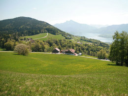
Very nice walkingpath with a wonderful view over the Mondsee and Irrsee lakes. fir-tree-path: about three hours walk
You start at the Mondseeberg. Drive up to the vista point (Aussichtsparkplatz II) and enjoy the view of Mondsee and the marvellous surrounding.
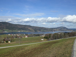
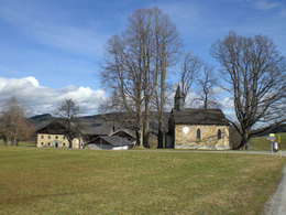
Drive further on to the bus-stop on your left. Park your car nearby. Beyond the bus-stop, on the left side, you see the fir-tree-signt. You'll find this sign along the whole way. Pass the farmhouses of Ebnat, then the path leads across the meadow, through the woods and to the small river Vöckla. Turn left to the Vöckla until you reach the little road. Follow this road, through to Harpoint, continuing to the Lindenbauernkapelle. Enjoy the nice view of Irrsee and Sommerholz. Follow now the signs through Lindau and Sulzberg back to the bus-stop near Hochmoor where your car is parked.
You start at the Mondseeberg. Drive up to the vista point (Aussichtsparkplatz II) and enjoy the view of Mondsee and the marvellous surrounding.
Drive further on to the bus-stop on your left. Park your car nearby. Beyond the bus-stop, on the left side, you see the fir-tree-signt. You'll find this sign along the whole way. Pass the farmhouses of Ebnat, then the path leads across the meadow, through the woods and to the small river Vöckla. Turn left to the Vöckla until you reach the little road. Follow this road, through to Harpoint, continuing to the Lindenbauernkapelle. Enjoy the nice view of Irrsee and Sommerholz. Follow now the signs through Lindau and Sulzberg back to the bus-stop near Hochmoor where your car is parked.
Wanderweg
- Suitable for kids (all ages)
- Spring
- Summer
- Autumn
- Early winter
- Deep winter
Please get in touch for more information.
Dr. Franz Müller Straße 3
5310 Mondsee am Mondsee
Phone +43 6232 2270
Fax machine +43 6232 2270 - 22
E-Mail info@mondsee.at
Web www.mondsee.at
http://www.mondsee.at
Interactive elevation profile
Create PDF
Tour-Details
Starting place: 5310 Tiefgraben am Mondsee
Destination: 5310 Tiefgraben am Mondsee
duration: 3h 31m
length: 11,4 km
Altitude difference (uphill): 352m
Altitude difference (downhill): 351m
Lowest point: 684m
Highest point: 886m
difficulty: easy
condition: medium
panoramic view: Some Views
Paths covering:
Asphalt, Gravel, Hiking trail
powered by TOURDATA