

Hans Pabst trail


- Suitable for families
- Suitable for kids (all ages)
- Flatly
Interactive elevation profile
Create PDF
Tour-Details
Starting place: 5310 Tiefgraben am Mondsee
Destination: 5310 Tiefgraben am Mondsee
duration: 3h 0m
length: 8,6 km
Altitude difference (uphill): 511m
Altitude difference (downhill): 538m
Lowest point: 496m
Highest point: 1.013m
difficulty: easy
condition: easy
panoramic view: Individual Views
Paths covering:
Street, Hiking trail
powered by TOURDATA
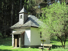
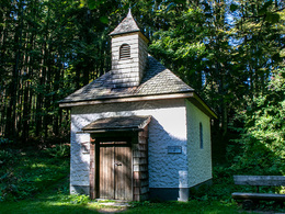
Round tour from the center of Mondsee to the hidden Radstatt Chapel on the Mondseeberg.
We start our beautiful circular hike in the center of Mondsee, directly at the St. Michael Basilica. From there we walk across the rectory and through the gate to the so-called "Gosaugraben". Here it goes steeply uphill through a settlement. At the end of the street, a narrow path leads to the right to the main street. We cross this street and immediately turn left on the other side. Now the hiking trail runs under the motorway and on hiking trail no.5 to the Riesnerhof (Ambiente am Riesnerhof) and on to the Radstatt Chapel. On the Radstatt-ridge we now follow hiking trail no. 2 until we reach a forest road. After a short part on the forest road, the hiking trail branches off to the left and we continue downhill. After the end of the hiking trail, we turn left and walk under the motorway again. Now we follow the course of Mondseebergstraße down towards Mondsee and then turn left onto Herzog Odilo Straße towards the town center. So we get back to our starting point. Starting point: Basilica St. Michael Mondsee in the center of Mondsee.
Destination: Basilica St. Michael Mondsee in the center of Mondsee.
further information:
- Flatly
Accessibility / arrival
The tour starts in the center of Mondsee - directly at the St. Michael basilica.
Parking on site.
- Parking space: 20
- Suitable for groups
- Suitable for kids (all ages)
- Suitable for teenagers
- Suitable for seniors
- Suitable for single travelers
- Suitable for friends
- Suitable for couples
- Suitable for children
- Spring
- Summer
- Autumn
- Early winter
- Deep winter
Please get in touch for more information.
Dr. Franz Müller Straße 3
5310 Tiefgraben am Mondsee
Phone +43 6232 2270
Fax machine +43 6232 2270 - 22
E-Mail info@mondsee.at
Web www.mondsee.at
http://www.mondsee.at
Interactive elevation profile
Create PDF
Tour-Details
Starting place: 5310 Tiefgraben am Mondsee
Destination: 5310 Tiefgraben am Mondsee
duration: 3h 0m
length: 8,6 km
Altitude difference (uphill): 511m
Altitude difference (downhill): 538m
Lowest point: 496m
Highest point: 1.013m
difficulty: easy
condition: easy
panoramic view: Individual Views
Paths covering:
Street, Hiking trail
powered by TOURDATA