

Saiherbachalm Alpine Meadow Tour


- Flatly
Interactive elevation profile
Create PDF
Tour-Details
Starting place: 4820 Bad Ischl
Destination: 4820 Bad Ischl
duration: 2h 19m
length: 18,0 km
Altitude difference (uphill): 879m
Altitude difference (downhill): 877m
Lowest point: 464m
Highest point: 1.029m
difficulty: medium
condition: medium
panoramic view: Individual Views
Paths covering:
Asphalt
powered by TOURDATA
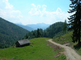
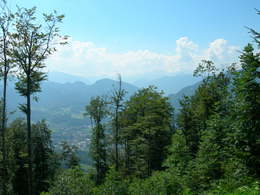
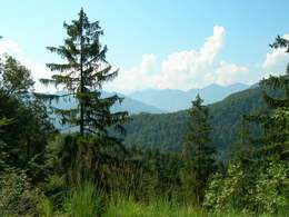
Starts and ends in Bad Ischl, offering spectacular views of Dachstein mountain and the town itself, a former retreat for Austro-Hungarian royalty. The trail rises and dips some 655 vertical metres, with its main sights being a quarry, Saiherbachalm alpine meadow and Schneeröselkogel peak. It consists variously of cycle paths, forest roads, trails and meadow tracks.
The tour starts at the visitor centre in Bad Ischl (Salzkammergut Touristik). At the start of the tour, we ride along the cycle path towards Ebensee/Gmunden. After the rock processing facility, we turn left onto the uphill forest road. From there, we begin a long ascent up to Schneeröselkogel peak. On the way up, we pass a quarry. Shortly before the end of the tour, we cycle beneath Saiherbachalm alpine meadow on a forest road leading to the Schneeröselkogel. Once at the top, we are rewarded with majestic views over Bad Ischl and the Dachstein. Following a detour to Saiherbachalm, we ride back downhill in the direction of Bad Ischl, taking the route along Saiherbach stream. The trail is quite badly washed out in places, so cycling skill is required here. After leaving the trail, we head around Jainzenberg hill via forest roads and meadow tracks, taking us back to Bad Ischl.
The tour starts at the visitor centre in Bad Ischl (Salzkammergut Touristik). At the start of the tour, we ride along the cycle path towards Ebensee/Gmunden. After the rock processing facility, we turn left onto the uphill forest road. From there, we begin a long ascent up to Schneeröselkogel peak. On the way up, we pass a quarry. Shortly before the end of the tour, we cycle beneath Saiherbachalm alpine meadow on a forest road leading to the Schneeröselkogel. Once at the top, we are rewarded with majestic views over Bad Ischl and the Dachstein. Following a detour to Saiherbachalm, we ride back downhill in the direction of Bad Ischl, taking the route along Saiherbach stream. The trail is quite badly washed out in places, so cycling skill is required here. After leaving the trail, we head around Jainzenberg hill via forest roads and meadow tracks, taking us back to Bad Ischl.
Starting point: Salzkammergut Visitor Centre (Tourismusinformation)
Destination: Salzkammergut Visitor Centre (Tourismusinformation)
further information:
- Flatly
Accessibility / arrival
How to get to Bad Ischl:
By car:
From Salzburg: B158 → Bad Ischl
From Vienna: A1 to Regau, B145 → Bad Ischl
By train:
Linz or Salzburg → Attnang-Puchheim → Bad Ischl
Graz → Stainach Irdning → Bad Ischl
Most economical season
- Summer
Please get in touch for more information.
4820 Bad Ischl
Phone +43 6132 27757
Fax machine +43 6132 27757 - 77
E-Mail office@badischl.at
Web www.badischl.at
http://www.badischl.at
Interactive elevation profile
Create PDF
Tour-Details
Starting place: 4820 Bad Ischl
Destination: 4820 Bad Ischl
duration: 2h 19m
length: 18,0 km
Altitude difference (uphill): 879m
Altitude difference (downhill): 877m
Lowest point: 464m
Highest point: 1.029m
difficulty: medium
condition: medium
panoramic view: Individual Views
Paths covering:
Asphalt
powered by TOURDATA