

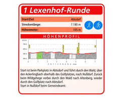
Round Lexenhof


- All weather
- Suitable for families
- Flatly
Interactive elevation profile
Create PDF
Tour-Details
Starting place: 4865 Nußdorf am Attersee
Destination: 4865 Nußdorf am Attersee
duration: 4h 5m
length: 16,4 km
Altitude difference (uphill): 85m
Altitude difference (downhill): 59m
Lowest point: 487m
Highest point: 543m
difficulty: medium
condition: medium
panoramic view: Great panorama
Paths covering:
Asphalt, Gravel, Hiking trail
powered by TOURDATA
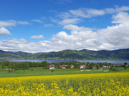
Beautiful and leisurely hike on the west side of Lake Attersee with refreshment stops.
Start is at the municipal office / info office in Nußdorf am Attersee.
From here you walk on the Kapellenweg past the game reserve, through the forest to Altenberg and further next to the golf course to Abtsdorf until you reach a small parking lot with an overview map. Following the markings you walk further over the Ackerlingbach through the forest and come back to Nußdorf via Winterleithen and Breitenröth. The Lexenhof circuit also takes you through the forest, so sturdy shoes are needed. For the most part, however, you walk on asphalt.
A parking lot is located at the municipal office or info office in Nußdorf am Attersee
Possible places to stop:
Starting point: Municipal Office - Tourist Information Office Parking place: Municipal Office - Tourist Information Office in Nußdorf am Attersee
Destination: Municipal Office - Tourist Information Office
further information:
- Flatly
all year
")
")
Accessibility / arrival
By car:
Freeway A1 exit St.Georgen -> direction Attersee, on the B151 to Nußdorf
Innkreisautobahn A8 to Ried, federal road via Vöcklamarkt, St. Georgen , Attersee, Nußdorf
By train:
Westbahn to Vöcklamarkt, by small train to Attersee station -> 4km to Nußdorf (bus connection)
- Parking space: 5
- All weather
- Suitable for groups
- Suitable for schools
- Suitable for teenagers
- Suitable for seniors
- Suitable for single travelers
- Suitable for friends
- Suitable for couples
- Suitable for children
- Spring
- Summer
- Autumn
- Early winter
Please get in touch for more information.
Dorfstraße 33
4865 Nußdorf am Attersee
Phone +43 7666 7719 - 40
E-Mail info.nussdorf@attersee.at
Web attersee-attergau.salzkammergut.at
https://attersee-attergau.salzkammergut.at
You can also visit us on
Visit us on Facebook Wikipedia")
")
 (© 1ser Beisl)")
")
Interactive elevation profile
Create PDF
Tour-Details
Starting place: 4865 Nußdorf am Attersee
Destination: 4865 Nußdorf am Attersee
duration: 4h 5m
length: 16,4 km
Altitude difference (uphill): 85m
Altitude difference (downhill): 59m
Lowest point: 487m
Highest point: 543m
difficulty: medium
condition: medium
panoramic view: Great panorama
Paths covering:
Asphalt, Gravel, Hiking trail
powered by TOURDATA