

Kalkalpen Trail stage 10


- Possible accommodation
Interactive elevation profile
Create PDF
Tour-Details
Starting place: 4573 Hinterstoder
Destination: 4573 Hinterstoder
duration: 5h 23m
length: 15,6 km
Altitude difference (uphill): 526m
Altitude difference (downhill): 1.298m
Lowest point: 584m
Highest point: 1.511m
difficulty: medium
condition: medium
panoramic view: Great panorama
Paths covering:
Asphalt, Hiking trail
powered by TOURDATA
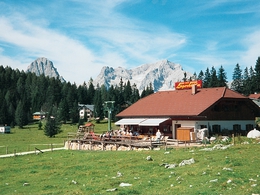
Edtbauernalm pasture - Hinterstoder
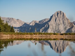
Theme: Alpinism The development of the 10th base is the theme of today’s stage. The World-Cup-Village Hinterstoder lies at the centre of tradition and tourism. All of which is well documented at the Alpineum, a modern museum. Situated in front of the impressive backdrop of the Tote Gebirge mountain range, you will end your day at the Schiederweiher pond. The 10th stage leads from the Hutterer Böden down via the Weißenbach valley, past the Polsterlucke and Schiederweiher, into the world cup village of Hinterstoder.
Theme: Alpinism The development of the 10th base is the theme of today’s stage. The World-Cup-Village Hinterstoder lies at the centre of tradition and tourism. All of which is well documented at the Alpineum, a modern museum. Situated in front of the impressive backdrop of the Tote Gebirge mountain range, you will end your day at the Schiederweiher pond. The 10th stage leads from the Hutterer Böden down via the Weißenbach valley, past the Polsterlucke and Schiederweiher, into the world cup village of Hinterstoder.
Starting point: Hutterer Böden Hinterstoder
Destination: Center - tourist office in Hinterstoder
further information:
- Possible accommodation
- Board possible
Details - hiking
- themed path

Accessibility / arrival
by car:
From Vorderstoder follow the signs Hinterstoder - At the crossroads turn left to Hinterstoder - valley station cable car
by train:
A9 motorway - exit St. Pankraz - then turn left - at GH Steyrbrücke left to Hinterstoder - valley station cable car
Most economical season
- Summer
Please get in touch for more information.
Hinterstoder 38
4573 Hinterstoder
Phone +43 7564 5263
Fax machine +43 7564 5263 - 30
E-Mail hinterstoder@pyhrn-priel.net
Web www.kalkalpenweg.at
Web www.urlaubsregion-pyhrn-priel.at
http://www.kalkalpenweg.at
https://www.urlaubsregion-pyhrn-priel.at
https://www.urlaubsregion-pyhrn-priel.at
Interactive elevation profile
Create PDF
Tour-Details
Starting place: 4573 Hinterstoder
Destination: 4573 Hinterstoder
duration: 5h 23m
length: 15,6 km
Altitude difference (uphill): 526m
Altitude difference (downhill): 1.298m
Lowest point: 584m
Highest point: 1.511m
difficulty: medium
condition: medium
panoramic view: Great panorama
Paths covering:
Asphalt, Hiking trail
powered by TOURDATA