

Hinterstoder Höss mountainbike tour MTB3


- Flatly
Interactive elevation profile
Create PDF
Tour-Details
Starting place: 4573 Hinterstoder
Destination: 4573 Hinterstoder
duration: 3h 48m
length: 29,6 km
Altitude difference (uphill): 1.000m
Altitude difference (downhill): 1.000m
Lowest point: 579m
Highest point: 1.400m
difficulty: difficult
condition: difficult
panoramic view: Great panorama
Paths covering:
Asphalt, Gravel
powered by TOURDATA
information: Akutmeldung/Information
Description: Experience shows that the MTB3 route is usually only accessible from the end of May/beginning of June due to the snow conditions.
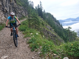
Hinterstoder - Hutterer Böden - Rottal - Schafferteich - Hutterer Seite - Wartegg - Hinterstoder
The start is at the large cable car parking lot at the entrance to Hinterstoder (free of charge). Here you turn left out of the valley and at the toll road turn right up (free for mountain bikers). This panorama road (asphalt) is approx. 10km long and rises steadily. From the Höss middle station, around 1 km flat, to the Edtbauernalm, at the youth guest house on the right and then left, along the alpine path below the Edtbauernalm refuge, past the edge of the terrain. Now first steeply sloping, with a wonderful view, push your bike (sliding distance - note the information boards!), Over the old alpine path, partly carved into rock, into the Rottal (1 km). The alpine path continues downhill rather bumpy past the lower Edtbauernalm on a forest road. This now climbs briefly until a forest road joins on the right, then slightly falling past the Steyrsbergerreith hiking trail confluence (1,193m, open from the beginning of July to the beginning of September). Further downhill slightly to a bend, then steeper straight down, then several bends, from the right a road joins again, down again flatter, past the service hut of the mountain rescue service Vorderstoder, follow the signs (several branches) you get to the Schafferteich (bathing possibility ).
Finally you reach the asphalt road (junction Binder and Ferienhof Großgrub). Falling further left on the asphalt road to the Schaffergut, you come straight ahead to Vorderstoder. However, the route leads sharply to the left following the Stodertal winter hiking trail to Hinterstoder. First downhill past an old forge, then slightly uphill on a gravel road to Eckhartgut, through the farmstead and flat further below the Hacklgut on the access road to Baumschlagerberg (1.5 km away). Follow this uphill to the left for a short while before branching off after the Bärengut to the Hutgrabner. Through the courtyard, further falling over a meadow path, then a gravel road, several bends through the forest down to the junction at the edge of the forest (several houses). Now left over the Knittelgraben up the paved path, over a ridge to the Luckerbauernbachl. To the left, the route continues, getting steeper and steeper, up around 300 meters to a small property (Bärensimmerl), now again flat through the forest to the Wartegg-Gut (809 m). The access road Wartegg down to the old toll road, and further down then left to the Landhotel Gressenbauer, and on to Hinterstoder to the starting point.
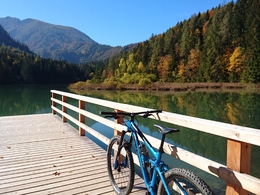
* Refreshments: Lögerhütte, Salettl, Edtbauernalm refuge, Steyrsbergerreith (beginning of July to beginning of September), Landhotel Gressenbauer
* Mountain bike circuit: approx. 30 km
* Difference in altitude: approx. 1,000 m
- Experience has shown that this route can only be used from the end of May due to its altitude and the winter damage.
* Of course, the route can also be traveled in the opposite direction.
* The route is signposted throughout!
* Riding the bike route from April 15th - 31.10. Permitted 2 hours after sunrise and up to 1 hour before sunset.
The start is at the large cable car parking lot at the entrance to Hinterstoder (free of charge). Here you turn left out of the valley and at the toll road turn right up (free for mountain bikers). This panorama road (asphalt) is approx. 10km long and rises steadily. From the Höss middle station, around 1 km flat, to the Edtbauernalm, at the youth guest house on the right and then left, along the alpine path below the Edtbauernalm refuge, past the edge of the terrain. Now first steeply sloping, with a wonderful view, push your bike (sliding distance - note the information boards!), Over the old alpine path, partly carved into rock, into the Rottal (1 km). The alpine path continues downhill rather bumpy past the lower Edtbauernalm on a forest road. This now climbs briefly until a forest road joins on the right, then slightly falling past the Steyrsbergerreith hiking trail confluence (1,193m, open from the beginning of July to the beginning of September). Further downhill slightly to a bend, then steeper straight down, then several bends, from the right a road joins again, down again flatter, past the service hut of the mountain rescue service Vorderstoder, follow the signs (several branches) you get to the Schafferteich (bathing possibility ).
Finally you reach the asphalt road (junction Binder and Ferienhof Großgrub). Falling further left on the asphalt road to the Schaffergut, you come straight ahead to Vorderstoder. However, the route leads sharply to the left following the Stodertal winter hiking trail to Hinterstoder. First downhill past an old forge, then slightly uphill on a gravel road to Eckhartgut, through the farmstead and flat further below the Hacklgut on the access road to Baumschlagerberg (1.5 km away). Follow this uphill to the left for a short while before branching off after the Bärengut to the Hutgrabner. Through the courtyard, further falling over a meadow path, then a gravel road, several bends through the forest down to the junction at the edge of the forest (several houses). Now left over the Knittelgraben up the paved path, over a ridge to the Luckerbauernbachl. To the left, the route continues, getting steeper and steeper, up around 300 meters to a small property (Bärensimmerl), now again flat through the forest to the Wartegg-Gut (809 m). The access road Wartegg down to the old toll road, and further down then left to the Landhotel Gressenbauer, and on to Hinterstoder to the starting point.
* Refreshments: Lögerhütte, Salettl, Edtbauernalm refuge, Steyrsbergerreith (beginning of July to beginning of September), Landhotel Gressenbauer
* Mountain bike circuit: approx. 30 km
* Difference in altitude: approx. 1,000 m
- Experience has shown that this route can only be used from the end of May due to its altitude and the winter damage.
* Of course, the route can also be traveled in the opposite direction.
* The route is signposted throughout!
* Riding the bike route from April 15th - 31.10. Permitted 2 hours after sunrise and up to 1 hour before sunset.
Starting point: Large parking lot of the cable car in Hinterstoder
Destination: Large parking lot of the cable car in Hinterstoder
further information:
- Flatly
- Board possible
details mountainbike
- Riding technique: difficult
Accessibility / arrival
Motorway A9: Exit Hinterstoder / St. Pankraz, then via the B138 to the Steyrbrücke and the L552 to Hinterstoder.
From the parking lot in Hinterstoder you either cycle up the 10km long toll road (free for mountainbikers) or by cable car to the middle station ( bike transport possible / fee).
The large cable car parking lot at the entrance to Hinterstoder is free, all other parking spaces in the village are chargeable.
- Suitable for single travelers
- Suitable for friends
- Suitable for couples
- Summer
- Autumn
Please get in touch for more information.

Hinterstoder 38
4573 Hinterstoder
Phone +43 7564 5263
Fax machine +43 7564 5263 - 30
E-Mail hinterstoder@pyhrn-priel.net
Web www.urlaubsregion-pyhrn-priel.at
https://www.urlaubsregion-pyhrn-priel.at
")
")

")

")
")
Interactive elevation profile
Create PDF
Tour-Details
Starting place: 4573 Hinterstoder
Destination: 4573 Hinterstoder
duration: 3h 48m
length: 29,6 km
Altitude difference (uphill): 1.000m
Altitude difference (downhill): 1.000m
Lowest point: 579m
Highest point: 1.400m
difficulty: difficult
condition: difficult
panoramic view: Great panorama
Paths covering:
Asphalt, Gravel
powered by TOURDATA