

Stubwieswipfel ski tour (tour area Wurzeralm)


- Possible accommodation
Interactive elevation profile
Create PDF
Tour-Details
Path number: A3
Starting place: 4582 Spital am Pyhrn
Destination: 4582 Spital am Pyhrn
duration: 1h 28m
length: 5,8 km
Altitude difference (uphill): 960m
Lowest point: 1.358m
Highest point: 1.738m
difficulty: easy
condition: easy
panoramic view: Great panorama
Paths covering:
snow
powered by TOURDATA
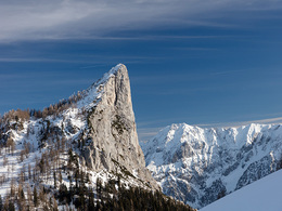
The ski tour to the Stubwieswipfel is a very scenic tour with spectacular views deep and well suited for all skill levels! From the Wurzeralm mountain station, drive down to the Linzerhaus and now cross the Teichlboden, straight to the Filzmoosalmen. From here it goes straight ahead through a sparse forest and on the forest road slightly uphill to just before the Stubwiesalmen. From the clearing at around 1,470 m, it now goes in a right-hand loop up the slope through a sparse larch forest, becoming ever steeper to a saddle. Now it goes back a bit flatter until the summit slope becomes visible on the right. You go up this in a few hairpin bends. Finally, go over the rocky summit ridge, which is mostly blown off, keeping to the right to the cross from the Stubwieswipfel. Here you have a brilliant overview of the south face, which breaks off vertically to the Wurzeralm, the Haller Walls and the Hohe Tauern.
From the valley station of the Wurzeralm funicular, follow the specially created touring trail along the funicular up to the Wurzeralm. Alternatively, you can of course also take the funicular. (about 600 meters less)
Departure:
How rise!
SAFETY INSTRUCTIONS:
From the valley station of the Wurzeralm funicular, follow the specially created touring trail along the funicular up to the Wurzeralm. Alternatively, you can of course also take the funicular. (about 600 meters less)
Departure:
How rise!
SAFETY INSTRUCTIONS:
- Do not leave the marked tour and departure zone!
- Use at your own risk!
- Know your own limits – avoid overexertion!
- Before starting the tour: check the avalanche warning (www.lawinen.report)
- Non-organized ski room - descent at your own risk!
- Good preparation is everything. Therefore we take into account the current weather and avalanche report for our tour.
- Wild parking creates chaos and traffic delays. That's why we start from the designated parking lot - or, where possible, let the local shuttle service take us to the starting point.
- We do not go on night ski tours outdoors. For ski tours on the piste, we adhere to the local piste rules.
- Winter is hard enough for the deer. That is why we keep the greatest possible distance from the animals and their feeding stations.
- We give a wide berth to young forest with trees under 3 m. Because there are young trees hidden under the snow cover, which we don't want to damage.
- Garbage has no place in nature. That's why we dispose of packaging, cigarette butts, dog waste bags, etc. in the nearest garbage can.
- What must be must be. We still look for each other to take care of the needs a place where no one will disturb you.
Starting point: Teichlboden
Destination: Stubwieswipfel
further information:
- Possible accommodation
- Board possible
Details - Ski
- Descent: difficulty: easy, 960 Metres of altitude
- Snowboard suitable
Accessibility / arrival
Exit the A9 Pyhrn autobahn in Spital am Pyhrn and follow the signs to the Wurzeralm valley station. From here you can take one of the ski tours to the Wurzeralm mountain station or use the Wurzeralm funicular.
Parking- Parking space: 2000
- Bus parking space: 100
Payment methods
Other payment methods
Cash payment
- Suitable for single travelers
- Suitable for friends
- Suitable for couples
- Early winter
- Deep winter
Please get in touch for more information.
Stiftsplatz 1
4582 Spital am Pyhrn
Phone +43 7563 249
Fax machine +43 7563 249 - 20
E-Mail spital@pyhrn-priel.net
Web www.urlaubsregion-pyhrn-priel.at
https://www.urlaubsregion-pyhrn-priel.at

")

Interactive elevation profile
Create PDF
Tour-Details
Path number: A3
Starting place: 4582 Spital am Pyhrn
Destination: 4582 Spital am Pyhrn
duration: 1h 28m
length: 5,8 km
Altitude difference (uphill): 960m
Lowest point: 1.358m
Highest point: 1.738m
difficulty: easy
condition: easy
panoramic view: Great panorama
Paths covering:
snow
powered by TOURDATA