

Schöneben Tour No. M7


- Flatly
- Possible accommodation
Interactive elevation profile
Create PDF
Tour-Details
Path number: M7
Starting place: 4252 Liebenau
Destination: 4252 Liebenau
duration: 1h 57m
length: 22,9 km
Altitude difference (uphill): 530m
Altitude difference (downhill): 530m
Lowest point: 821m
Highest point: 1.050m
difficulty: easy
condition: easy
panoramic view: Some Views
Paths covering:
Asphalt, Hiking trail
powered by TOURDATA
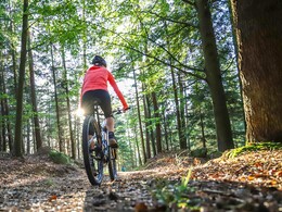
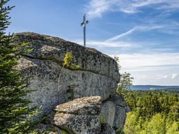
This tour takes you to the highest point of Liebenau, the Brockenberg. After your start in Liebenau, you will ride through the towns of Maxldorf and Schöneben. The tour then takes you through a longer stretch of woodland to the Weiße Aist (Weiße Aist river) and continues to the town of Liebenstein. Here you will encounter the legendary granite formation "Jankusmauer". The so-called "Teufelskessel" (Devil's Basins), where one is always dry and the other is always filled with water, are true energy sources for "recharging". On a ride to the highest point of Liebenau, the Brockenberg. (1058 m), you will reach the starting point of this tour again.
Accessibility / arrival
From Linz coming by car: via A7 and L1472
1 h 4 min, 57.4 km
- Suitable for groups
- Suitable for teenagers
- Suitable for single travelers
- Suitable for friends
- Suitable for couples
- Spring
- Summer
- Autumn
Please get in touch for more information.
Liebenau 41
4252 Liebenau
Phone +43 7953 8111
E-Mail office@muehlviertleralm.at
Web www.muehlviertleralm.at
Web www.tourdealm.at
http://www.muehlviertleralm.at
http://www.tourdealm.at
http://www.tourdealm.at
Interactive elevation profile
Create PDF
Tour-Details
Path number: M7
Starting place: 4252 Liebenau
Destination: 4252 Liebenau
duration: 1h 57m
length: 22,9 km
Altitude difference (uphill): 530m
Altitude difference (downhill): 530m
Lowest point: 821m
Highest point: 1.050m
difficulty: easy
condition: easy
panoramic view: Some Views
Paths covering:
Asphalt, Hiking trail
powered by TOURDATA