

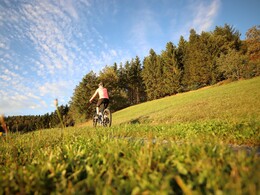
Hirschalm Tour No. M4


- culturally interesting
- Flatly
Interactive elevation profile
Create PDF
Tour-Details
Path number: M4
Starting place: 4273 Unterweißenbach
Destination: 4273 Unterweißenbach
duration: 3h 27m
length: 52,2 km
Altitude difference (uphill): 1.846m
Lowest point: 850m
Highest point: 974m
difficulty: medium
condition: medium
panoramic view: Individual Views
Paths covering:
Asphalt, Hiking trail
powered by TOURDATA
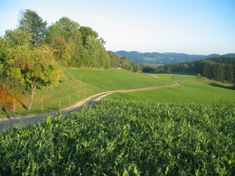
The mountain bike route starts at the Hirschalm (Hirschalm mountain pasture) and leads via Leopoldstein, Pernedt, Salchenedt and Ebmer Häuser back to the Hirschalm. From the Jagdmärchenpark (hunter's fairy-tale park), the trail leads you to the town of Greinerschlag, further on to the “Glashüttenkreuz” over the Multererberg to the Moserwirt (good location for a break) and then uphill to the “Binder Hermann” intersection (connection to the Bärenwaldstrecke (Bärenwald route) - Waldviertel MTB trail network). From there, you will follow the road to the B124 intersection. The trail carries on through the quiet forest, uphill and downhill, to Hörzenschlag, Stifting, further on to the town of Pernedt.
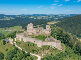
Via the Paroxedt commercial road, you will reach Ebrixedt (connection to St. Georgen am Walde - MTB route), then ride downhill all the way to the Nussbach (Nussbach brook), which you follow until you reach the Holzmann cross. Via Salchenedt, Kappermühle, you will set out to see the Ruttenstein ruins - another highlight on this route. From there, the trail takes you via Mötlas back to the starting point at the Jagdmärchenpark Hirschalm.
Furthermore, there is a connection to the Königswiesen circular tour from the Hirschalm (shortcut, summit cross - wonderful view, town of Königswiesen).
Starting point: Jagdmärchenpark Hirschalm (Hirschalm hunter's fairy tale park)
Destination: Jagdmärchenpark Hirschalm (Hirschalm hunter's fairy tale park)
further information:
- Flatly
Accessibility / arrival
From Linz coming by car: via A7 and Königswiesener Str./B124
54 min., 54.4 km
- Suitable for groups
- Suitable for teenagers
- Suitable for seniors
- Suitable for single travelers
- Suitable for friends
- Suitable for couples
- Spring
- Summer
- Autumn
Please get in touch for more information.
4273 Unterweißenbach
Phone +43 7956 7304
Fax machine +43 7956 7304 - 4
E-Mail office@muehlviertleralm.at
Web www.muehlviertleralm.at
http://www.muehlviertleralm.at
Interactive elevation profile
Create PDF
Tour-Details
Path number: M4
Starting place: 4273 Unterweißenbach
Destination: 4273 Unterweißenbach
duration: 3h 27m
length: 52,2 km
Altitude difference (uphill): 1.846m
Lowest point: 850m
Highest point: 974m
difficulty: medium
condition: medium
panoramic view: Individual Views
Paths covering:
Asphalt, Hiking trail
powered by TOURDATA