

road "Schrattenbachstraße" in Gmunden


Interactive elevation profile
Create PDF
Tour-Details
Starting place: 4810 Gmunden
Destination: 4810 Gmunden
duration: 0h 58m
length: 3,1 km
Altitude difference (uphill): 111m
Altitude difference (downhill): 76m
Lowest point: 914m
Highest point: 977m
difficulty: medium
condition: medium
panoramic view: Great panorama
Paths covering:
Hiking trail
powered by TOURDATA
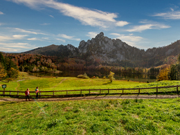
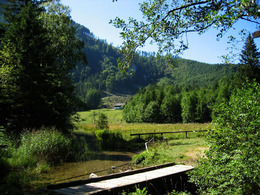
Starting point of this tour is "Franzl im Holz". Downhill the Kohlbachweg-in the direction Kranichsteg-across the rivulet "Laudach" uphill-second bridge turn left-Schrattenau-St.Konrad-Laudachsee
You can walk around the lake Laudachsee or enjoy a drink in the "Ramsauer Alm".
You can walk around the lake Laudachsee or enjoy a drink in the "Ramsauer Alm".
Starting point: Franzl im Holz
Destination: lake Laudachsee
")
karl_heinz_ruber (8) (© Foto: TVB Traunsee-Almtal/Karl-Heinz Ruber)")
Accessibility / arrival
from the highway: departure Regau-B 145 in the direction of Bad Ischl-through the center of Gmunden-across the bridge "Traunbrücke"-traffic circle first exit-in front of the Gasthof Engelhof turn right to Franzl im Holz
Most economical season
- Summer
Please get in touch for more information.
Toscanapark 1
4810 Gmunden
Phone +43 7612 74451
E-Mail info@traunsee-almtal.at
Web www.traunsee-almtal.at
http://www.traunsee-almtal.at
Interactive elevation profile
Create PDF
Tour-Details
Starting place: 4810 Gmunden
Destination: 4810 Gmunden
duration: 0h 58m
length: 3,1 km
Altitude difference (uphill): 111m
Altitude difference (downhill): 76m
Lowest point: 914m
Highest point: 977m
difficulty: medium
condition: medium
panoramic view: Great panorama
Paths covering:
Hiking trail
powered by TOURDATA