

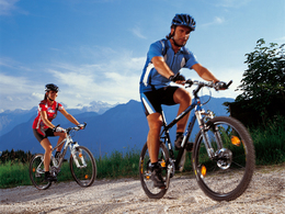
Richtberg MTB


Interactive elevation profile
Create PDF
Tour-Details
Starting place: 4852 Weyregg am Attersee
Destination: 4852 Weyregg am Attersee
duration: 3h 17m
length: 33,9 km
Altitude difference (uphill): 1.115m
Altitude difference (downhill): 1.107m
Lowest point: 474m
Highest point: 854m
difficulty: medium
condition: medium
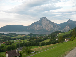
panoramic view: Great panorama
Paths covering:
Asphalt
powered by TOURDATA
We start at the Tourist Information Weyregg and take the road to Altmünster / Reindlmühl Gahberg direction and drive uphill to the village stream. Here we turn left and continue on the paved access road eight kilometers to Gahberg, where the road gets quite steep.The winding roads continue to a 864-meter-high vantage point. Magnificent views to the mountains and on the Attersee compensate the arduous journey. In the antenna, we turn right, pass the Alpengasthof Kogler (highest point of the round, 835 m) and flat ride along the ridge towards the woods. Now begins a long descent through the forest towards Reindlmühl. Along the way we can make a short detour to the left to the cozy inn Kreuzing pasture (500 m dead end), right, the road winds downhill and eventually goes into the forest road. This follows road proceeds down along the picturesque river. Caution - there are no street rails! At the next intersection we turn right to Reindlmühl, go straight at the Hotel Schachinger and after 2 km turn right in the direction Hochkreut. We will now remain on the steep mountain dirt trail Herzogenaurach, into small mountain we turn right and follow the forest road just downhill and then uphill again to Schwarzenbach saddle (799 m). Here our descent into the valley of the river Weyregger, where the road is at times quite close. We pass the bar and reach the district of Bach, where a narrow asphalt road that brings us back to Weyregg.
Attractions:
K.u.K. House-Museum
"In the Footsteps of the Habsburgs'
Austro the Landgasthof Zur Post Hoarstub'n (when Bruckbacherhof), built about 1850 for flat processing Roman mosaics in the elementary school Attersee shipping (bicycle transport)
Attractions:
K.u.K. House-Museum
"In the Footsteps of the Habsburgs'
Austro the Landgasthof Zur Post Hoarstub'n (when Bruckbacherhof), built about 1850 for flat processing Roman mosaics in the elementary school Attersee shipping (bicycle transport)
details mountainbike
- Riding technique: medium
Most economical season
- Summer
Please get in touch for more information.
Weyreggerstraße 69
4852 Weyregg am Attersee
Phone +43 7666 7719 - 70
E-Mail info.weyregg@attersee.at
Web attersee-attergau.salzkammergut.at
https://attersee-attergau.salzkammergut.at
You can also visit us on
Visit us on Facebook Visit our videochannel on YouTube WikipediaInteractive elevation profile
Create PDF
Tour-Details
Starting place: 4852 Weyregg am Attersee
Destination: 4852 Weyregg am Attersee
duration: 3h 17m
length: 33,9 km
Altitude difference (uphill): 1.115m
Altitude difference (downhill): 1.107m
Lowest point: 474m
Highest point: 854m
difficulty: medium
condition: medium
panoramic view: Great panorama
Paths covering:
Asphalt
powered by TOURDATA