

3rd Stage: Schafberg - Mondsee


- Multi-day tour
Interactive elevation profile
Create PDF
Tour-Details
Starting place: 5360 St. Wolfgang im Salzkammergut
Destination: 5310 Mondsee am Mondsee
duration: 8h 39m
length: 26,7 km
Altitude difference (uphill): 662m
Altitude difference (downhill): 1.914m
Lowest point: 480m
Highest point: 1.748m
difficulty: medium
condition: medium
panoramic view: Great panorama
powered by TOURDATA
This is one of the stages of the Long Distance Hike Fuschlsee, Wolfgangsee and Mondsee. The route leads from Fürberg on Lake Wolfgang to the centre of the resort of Mondsee. If required we offer you luggage transportation i.e. hiking without baggage. This stage of the Long Distance Hike Fuschlsee, Wolfgangsee and Mondsee starts at the boat jetty in Fürberg. From here you hike uphill to Winkl where you pass the Europa Monastry Gut Aich. Along the edge of the woods you reach the Schloss Hüttenstein and the Krotten Lake, one of 76 lakes in the Salzkammergut Lake District.
We cross the road to Gasthof Batzenhäusl (the last place for refreshment for 3 hours) and walk through the Zeppenezau valley of green meadows. At the end of the valley there is a climb to the Obenauer pasture ( not farmed).
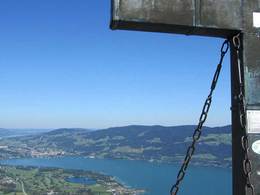
Almost at the highest point of the pasture to the right, next to the path, there is a fresh water spring under a tree. We continue and arrive at the steepest, but shortest climb, of today´s hike. The climb leads us through the wood to a cross-road in the middle of the woods. Turn left here, and follow the woodland path towards the Almkogel which rises slowly. After about 500m the woodland path becomes stoney. Shortly you will reach an exposed point which gives you fantastic views from Mondsee to the Attersee. It is now just a few metres to the half-way point of the tour, the Almkogel, the highest peak of today´s tour. Enjoy the view across Lake Mondsee to Lake Irrsee and into the Salzburg Lower Alps before you begin your descent.
The descent from the Almkogel peak leads in a twisting path down the the Klausbach stream. Cross over and stop shortly at the Thelka Chapel for a moments pause. After a few hundred metres you reach the Gasthof Drachenwand where you can retank your energy,
The tour continues along a fairly traffic-free side road through the area of Schwarzindien on Lake Mondsee and further along the lake shore to the end of the tour in the resort of Mondsee.
We cross the road to Gasthof Batzenhäusl (the last place for refreshment for 3 hours) and walk through the Zeppenezau valley of green meadows. At the end of the valley there is a climb to the Obenauer pasture ( not farmed).
Almost at the highest point of the pasture to the right, next to the path, there is a fresh water spring under a tree. We continue and arrive at the steepest, but shortest climb, of today´s hike. The climb leads us through the wood to a cross-road in the middle of the woods. Turn left here, and follow the woodland path towards the Almkogel which rises slowly. After about 500m the woodland path becomes stoney. Shortly you will reach an exposed point which gives you fantastic views from Mondsee to the Attersee. It is now just a few metres to the half-way point of the tour, the Almkogel, the highest peak of today´s tour. Enjoy the view across Lake Mondsee to Lake Irrsee and into the Salzburg Lower Alps before you begin your descent.
The descent from the Almkogel peak leads in a twisting path down the the Klausbach stream. Cross over and stop shortly at the Thelka Chapel for a moments pause. After a few hundred metres you reach the Gasthof Drachenwand where you can retank your energy,
The tour continues along a fairly traffic-free side road through the area of Schwarzindien on Lake Mondsee and further along the lake shore to the end of the tour in the resort of Mondsee.

Most economical season
- Summer
- Autumn
Please get in touch for more information.
Dr. Franz Müller Str. 3
5310 Mondsee am Mondsee
Phone +43 6232 2270
E-Mail info@mondsee.at
Web mondsee.salzkammergut.at
Web www.wanderbetriebe.at
http://mondsee.salzkammergut.at
http://www.wanderbetriebe.at
http://www.wanderbetriebe.at
Interactive elevation profile
Create PDF
Tour-Details
Starting place: 5360 St. Wolfgang im Salzkammergut
Destination: 5310 Mondsee am Mondsee
duration: 8h 39m
length: 26,7 km
Altitude difference (uphill): 662m
Altitude difference (downhill): 1.914m
Lowest point: 480m
Highest point: 1.748m
difficulty: medium
condition: medium
panoramic view: Great panorama
powered by TOURDATA