

Hargassner-Runde - Bewegungsarena


- Suitable for families
- Suitable for kids (all ages)
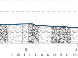
Interactive elevation profile
Create PDF
Tour-Details
Starting place: 4950 Altheim
Destination: 4950 Altheim
duration: 3h 28m
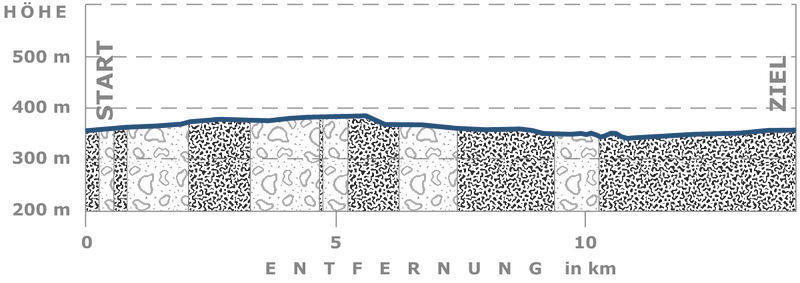
length: 14,2 km
Altitude difference (uphill): 37m
Altitude difference (downhill): 38m
Lowest point: 340m
Highest point: 385m
difficulty: medium
condition: medium
panoramic view: No view
Paths covering:
Asphalt, Gravel
powered by TOURDATA
information: Akutmeldung/Information
Hargassner loop - movement arena
From the Altheim town office, the Hargassner loop leads past the parish church of St. Laurentius to Diepolding and on to the municipality of Weng im Innkreis, where there is the opportunity to take a rest on a comfortable sun bench. The further course of the route leads to Appersting and on towards Gundholling. Along the Ache it goes back to Altheim.
From the Altheim town office, the Hargassner loop leads past the parish church of St. Laurentius to Diepolding and on to the municipality of Weng im Innkreis, where there is the opportunity to take a rest on a comfortable sun bench. The further course of the route leads to Appersting and on towards Gundholling. Along the Ache it goes back to Altheim.
- Suitable for groups
- Suitable for kids (all ages)
- Suitable for single travelers
- Suitable for friends
- Suitable for couples
- Spring
- Summer
- Autumn
Please get in touch for more information.
Braunauer Straße 7
4950 Altheim
Phone +43 7723 42255
Fax machine +43 7723 4225587
E-Mail office@altheim.ooe.gv.at
Web www.altheim.ooe.gv.at
http://www.altheim.ooe.gv.at
Interactive elevation profile
Create PDF
Tour-Details
Starting place: 4950 Altheim
Destination: 4950 Altheim
duration: 3h 28m
length: 14,2 km
Altitude difference (uphill): 37m
Altitude difference (downhill): 38m
Lowest point: 340m
Highest point: 385m
difficulty: medium
condition: medium
panoramic view: No view
Paths covering:
Asphalt, Gravel
powered by TOURDATA